Farming from the eastern Fertile Crescent
Full crop-only world map and combined western–eastern Eurasia version →
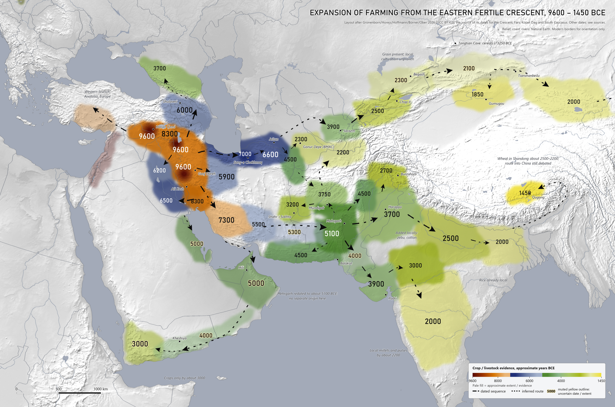
The eastern branch of the first farmers, from eastern Anatolia and north-west Iran down the Zagros, out to Central Asia, the Indian subcontinent and Arabia. Same approach as the Gronenborn map of Europe: colored zones by date, date labels, dashed arrows.
From your reference map
Gronenborn, Horejs, Hoffmann, Börner and Ober, 2026.2.
| 9600 | Upper Tigris, north-west Iran, central Zagros |
| 8300 | Eastern arc of the Crescent, Khuzestan |
| 7300 | Fars |
| 6600 | South-east Caspian and Kopet Dag |
| 6000 | South Caucasus |
Backed by a journal or specialist source
Map labels are rounded BCE dates. The evidence below distinguishes local cultivation, grain presence, herding and contact; a dated site does not establish farming across the entire colored zone.
| 7000 | Sang-e Chakhmaq, late 8th to early 7th millennium. Earlier than the surrounding 6600 zone. Antiquity |
| 5900 | Iranian plateau: Sialk begins before 5841–5679 Sialk chronology poster |
| 5500 | Kerman: Tepe Yahya VII, older dates awaiting redating Iranica |
| 5100 | Mehrgarh, cemetery start 5223–4914 Mutin et al. 2025 |
| Inferred or uncertain: 5000 | Gulf coast: Dosariyah, Ubaid contact and herds, no crops shown Drechsler 2018 |
| 2500 | Middle Ganges wheat and barley, 2500–2000 at the earliest Fuller 2011 |
| 2500 | Central Tian Shan: Chap II in Kyrgyzstan, occupation modeled to 2474–2162 cal BCE. Wheat and barley chaff support local cultivation and processing. This highland evidence does not date farming throughout the Fergana basin. Motuzaite Matuzeviciute et al. 2022 |
| 2300 | Margiana oasis farming, BMAC period Togolok 1 |
| Inferred or uncertain: 2300 | Semirechye: directly dated Begash wheat and millet, 2460–2150 cal BCE. The grain comes mainly from funerary contexts; exchange is plausible and local cultivation at this date is unproven. Frachetti et al. 2010 |
| 2000 | Gansu: Donghuishan wheat and barley, early 2nd millennium Flad et al. |
| 2000 | Deccan wheat and barley, 2000–1900, possibly 2200 South Deccan Prehistory Project |
| 1850 | North-eastern Tarim: Gumugou wheat directly dated to 1886–1746 cal BCE. The mapped connection from the eastern Tian Shan is inferred. Scientific Reports 2021, Table 3 |
| 3250 | Tongtian Cave in the Altai: wheat and barley around 5200 cal BP, approximately 3250 BCE. This older northern cereal occurrence is separate from the later Chap–Begash sequence. Cereal presence does not by itself establish local cultivation or a continuous settled corridor. Zhou et al. 2020 |
| 1450 | Central Tibet: Qugong crop assemblage, approximately 3400 cal BP (1450 BCE). Gao et al. 2021. A newer model places the site's early phase at 1400–1300 cal BCE; the rounded crop label follows the 2021 archaeobotanical study. Chen et al. 2024. The map uses a schematic southern Himalayan connection from the Ganges through Assam and around the eastern Himalaya into Qugong; the exact path is inferred. Southern Himalayan route discussion |
Weak or conflicting
Estimated connections and dates supported by secondary sources or conflicting chronologies.
| Inferred or uncertain: 5300 | Iranian Baluchistan, linking Kerman to Mehrgarh. Interpolated, no site date. |
| 6500 | Southern Mesopotamia: Ubaid 0 at Oueili, 6500–6000. Few radiocarbon dates. Wikipedia |
| 6200 | Samarra. Conflict: sources give 6200–5700, 5700–4900 and 5500–4800. Wikipedia |
| Inferred or uncertain: 5000 | Oman: inferred herding date; no direct site date is assigned to this zone. |
| Inferred or uncertain: 4000 | Las Bela and Sindh: an inferred connecting extent based on broad archaeological phases. Traditional Balakot chronologies may begin near 4000; Amri sites belong to the 4th millennium, with some Lower Sindh shell middens dated to its first half. These dates do not establish continuous farming along the whole connection to Gujarat. Biagi |
| Inferred or uncertain: 4000 | Hadramawt: the inland Kheshiya cattle-skull monument in Wadi Sana supports cattle pastoralism in the 5th millennium BCE, rather than a coastal crop-farming date. The map's coastal extent and rounded connecting date are inferred. Martin and Roe 2020 |
| Inferred or uncertain: 2100 | Dzungaria and eastern Tian Shan: an interpolated connection toward Gansu. Tianshanbeilu's modeled cemetery start falls within 2022–1802 cal BCE; this is uncertainty in its start date, not its full occupation interval or a direct date for local farming. Radiocarbon chronology |
| 4500 | Makran: Miri Qalat I, 5th millennium Wikipedia |
| 4500 | Bannu: Sheri Khan Tarakai, 4500–3500 Wikipedia |
| 4500 | Tedzhen delta: estimated by comparison with early Anau UNESCO |
| 3900 | Gujarat: Anarta tradition from about 3950. Farming in the earliest layers is not confirmed. Wikipedia |
| 3900 | Sarazm: radiocarbon dates 3900–2100 UNESCO |
| 3750 | Mundigak I. Conflict: 4500–4000, 4000–3500 and 3750–3500. Wikipedia |
| 3700 | Indus plain: Ravi phase at Harappa from about 3700. Conflict: Hakra is given as 3300–2800, and a much older Bhirrana claim is not used here. Abhidha, citing Kenoyer |
| 3700 | North Caucasus: Maykop, about 3700–3000 Wikipedia |
| 3200 | Sistan: Shahr-i Sokhta UNESCO |
| Inferred or uncertain: 3000 | Yemen highlands. Herds came first, crops were late. Dates from Khawlan are uncalibrated. Costantini 1984 |
| 3000 | Mewar: Balathal, start of the 3rd millennium. Conflict: Ahar also dated 2025–1270. Wikipedia |
| 2700 | Kashmir: Burzahom. Conflict: radiocarbon list runs 2100–1530. Swat not checked. Wikipedia |
| 2200 | Bactria: Dashly, 2300–2000. Tilla Bulak may be earlier; no date is assigned here. Wikipedia copy |
| 2000 | Lower Ganges: unconfirmed estimate |
How to read it
- Neighboring zones touch to make the regional sequence legible; gaps retain major deserts and high mountains. Their hand-drawn boundaries are approximate, not surveyed limits or proof of continuous settlement.
- Muted yellow date outlines and pale color identify interpolated dates, uncertain geographical extents, or evidence for grain presence, herding or contact rather than established local crop cultivation. Arrows are schematic connections; inferred routes remain hypotheses.
- Older accounts date Mehrgarh to about 7000 BCE. The 2025 study dates its cemetery, so earlier occupation at the site is not fully ruled out. Either way, its wheat and barley came from the west.
- Arrows show crops and herding moving, not necessarily people. Indus Valley genomes have Iranian-related ancestry that split from the Zagros farmer line before farming began (Shinde et al. 2019).
- East of the Indus, these crops joined local farming: rice on the Ganges, millets and pulses in the south, millet in China.
- The Levant and central Anatolia appear faintly to orient the western branch, whose expansion belongs to the western map.