Crop agriculture · World and Eurasia
The spread of crop agriculture
Regional cultivation histories in a single chronological map. Updated South American and African regions share their boundaries with the interactive atlas; deserts, high plateaus and selected oasis corridors use the same corrected geography.
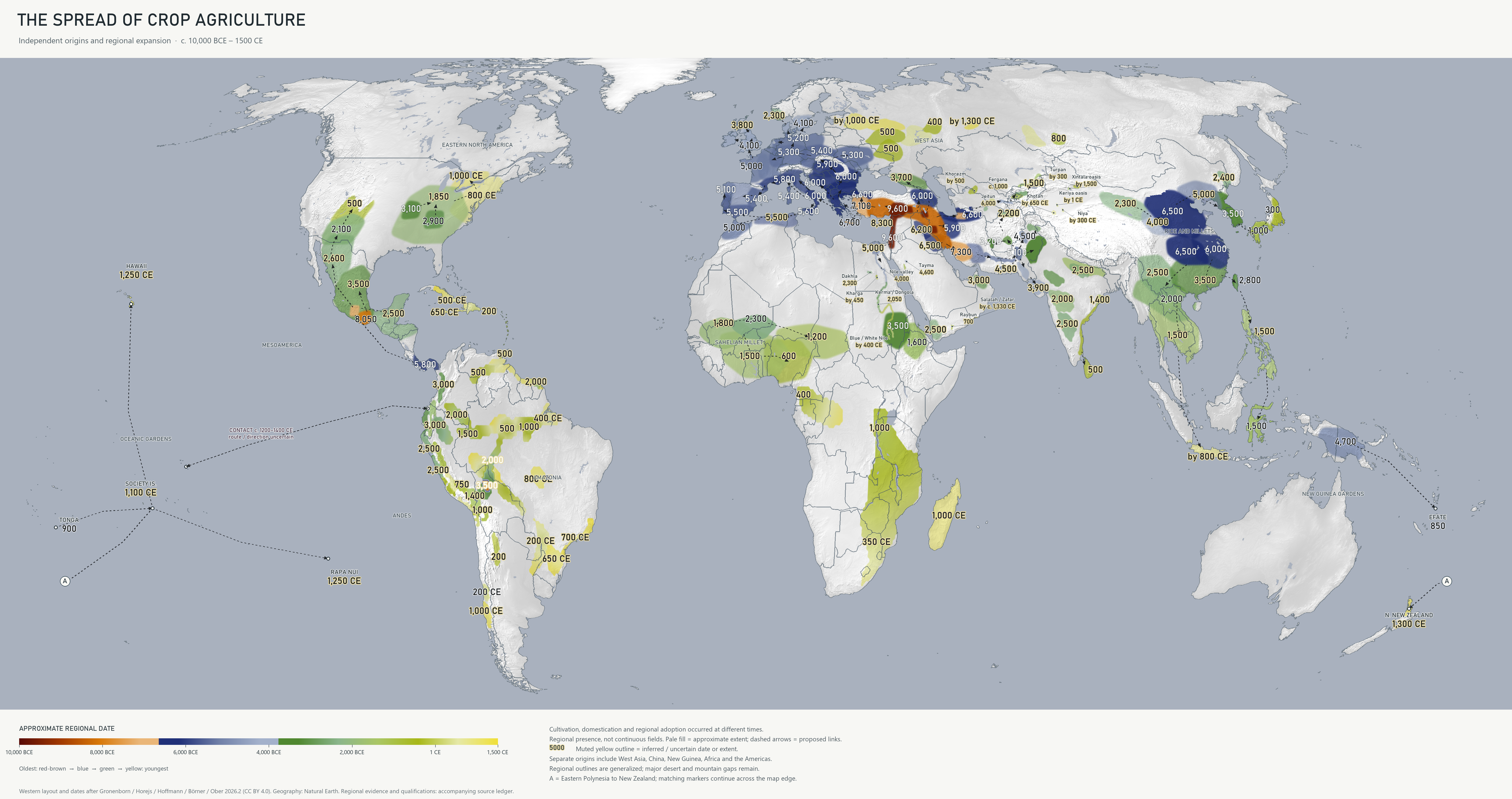
Regional dates and evidence
Rounded BCE and CE dates. Expand a region to inspect the underlying milestone and source; some small or crowded map labels appear only here. The oldest cultivation evidence does not necessarily date fully domesticated crops or farming across the entire polygon.
African crop histories 18 regions
| Date | Crop cultivation or adoption milestone | Source |
|---|---|---|
| 3,500 BCE | Eastern Sudan: local sorghum cultivation and domestication Wild and domestic-type spikelet traits coexist in fourth-millennium BCE evidence. This is a local crop-domestication process, not the independent origin of every form of farming or livestock in Sudan. | Winchell et al. 2017, Sorghum domestication in eastern Sudan |
| Inferred or uncertain: by 2,700 BCE | Lower Nubian Nile and Sai cultivation Sai cereal production supplies the rounded horizon for this approximate Lower Nubian river corridor. Its wider extent and date remain inferred, not a simultaneous first arrival at every cataract. | Hildebrand and Schilling 2016, Storage amidst early agriculture along the Nile: perspectives from Sai Island, Sudan |
| 2,300 BCE | Western Sahel: domestic pearl millet Rounded Lower Tilemsi cultivation/domestication horizon. The irregular regional envelope follows the Sahel/Lower Tilemsi setting; its northern edge is an illustrative extent, not a measured ancient climatic boundary. | Manning et al. 2011, 4500-year-old domestic pearl millet from Mali |
| Inferred or uncertain: 2,300 BCE | Dakhla: Old Kingdom oasis farming Local late-Old-Kingdom agricultural adoption; the earlier Bashendi and Sheikh Muftah pastoral record is not treated as equivalent crop farming. | Thanheiser, Introduction of Agriculture in Dakhleh: archaeobotanical project final report |
| Inferred or uncertain: 2,050 BCE | Kerma / Northern Dongola Reach: floodplain cultivation A narrow, enlarged alluvial envelope around Kerma and the Northern Dongola Reach. The date marks regional expansion of flood-recession farming, not an independent origin or cultivation of the western Sudanese desert. | Le Moyne et al. 2023, Dietary shifts between the Neolithic and Kerma periods at Kadruka |
| Inferred or uncertain: by 2,050 BCE | Kerma and Dongola Nile cultivation corridor A regional alluvial corridor around the Kerma/Dongola evidence; 2050 BCE is a conservative agricultural-intensification cue, not the first cultivation of the entire reach. The original Kerma/Dongola callout is retained. | Le Moyne et al. 2023, Dietary shifts between the Neolithic and Kerma periods at Kadruka |
| Inferred or uncertain: 1,800 BCE | Western Sahel: millet farming expansion Regional synthesis; agriculture did not cover the Sahara continuously. The cartographic envelope bends through the western Sahel rather than following a fixed parallel; its date and wider extent remain approximate. | Beldados et al. 2018, Early African crop evidence and exchange |
| 1,600 BCE | Northern Ethiopian highlands: mixed crops Mezber anchors the date. Indigenous crop domestication histories remain uncertain. | Ruiz-Giralt et al. 2023, On the verge of domestication: early C4 plant use in the Horn |
| Inferred or uncertain: 1,500 BCE | West African savannas: millet and local crops Approximate adoption region; yam and other vegetative crops lack a comparable precise first date. | Beldados et al. 2018, Early African crop evidence and exchange |
| Inferred or uncertain: 1,200 BCE | Southern Lake Chad Basin: pearl millet cultivation Gajiganna crop evidence dates the local horizon; the wider southern Sahel extent is inferred and does not extend through the Sahara. | Magnavita et al., Gajiganna crop sequence in the Lake Chad Basin |
| Inferred or uncertain: 1,000 BCE | Introduced farming: Great Lakes to southeastern Africa The date is an authored regional reconstruction input, not a directly dated first-arrival event or an independent domestication origin. Connected, bounded summer-rainfall corridor. Exact edges and intermediate arrival times are an authored scenario; western deserts, the Cape winter-rainfall region and highland interiors are not filled by a South African origin seed. Coverage and intermediate timing use the same bounded cultivation grid as the interactive atlas. Color summarizes cultivation presence, not continuous fields. | Isern & Fort 2019, Archaeological models of farming spread into eastern and southeastern Africa |
| Inferred or uncertain: 600 BCE | Central Nigeria and Benin: millet and cowpea Rounded from reported 800–400 BCE crop finds. | 2022, Iron Age plant subsistence in the Inner Congo Basin |
| Inferred or uncertain: by 450 BCE | Southern Kharga: irrigated cereal fields A documented-by Persian-period horizon for the Ayn Manawir / southern Kharga basin. Gaps between oases stay unfilled. | Agut-Labordere, Collection, storage and distribution of cereals at Ayn Manawir, Kharga Oasis |
| Inferred or uncertain: 400 BCE | Central African crop attestations The date is an authored regional reconstruction input, not a directly dated first-arrival event or an independent domestication origin. Conservative authored envelope around southern Cameroon and Inner Congo evidence, not continuous cultivated forest or the full extent of Bantu-speaking populations. Coverage and intermediate timing use the same bounded cultivation grid as the interactive atlas. Color summarizes cultivation presence, not continuous fields. | Neumann, Eichhorn & Wotzka 2022, Iron Age plant subsistence in the Inner Congo Basin |
| Inferred or uncertain: by 1 CE | Middle Nile: Dongola, great bend and Meroe to Khartoum The by-1-CE cue summarizes established Meroitic river farming. Older farming in northern reaches is shown by the earlier local records. The mapped corridor follows the Nile, leaving the Bayuda interior unfilled. | Fuller 2015, The economic basis of the Qustul splinter state: cash crops, subsistence shifts and labour demands |
| Inferred or uncertain: 350 CE | Eastern southern Africa: introduced cereal farming The rounded third/fourth-century CE horizon describes introduced farming communities in northern/eastern southern Africa, not a local domestication centre. This small ring is a label/ledger window only and never paints farmland or seeds the solver. The crop boundary and modeled arrival gradient instead follow the connected Great Lakes-to-southeastern corridor. Connected, bounded summer-rainfall corridor. Exact edges and intermediate arrival times are an authored scenario; western deserts, the Cape winter-rainfall region and highland interiors are not filled by a South African origin seed. | Becher et al. 2024, Multi-purpose pots at Lydenburg Heads |
| Inferred or uncertain: by 400 CE | Central Sudan: Blue and White Nile cultivation reaches A by-400-CE regional cue based on Abu Geili and Jebel Tomat domestic sorghum. The two watered reaches are enlarged for display and do not imply that every intervening part of the Gezira was cultivated at that date. | Fuller 2015, The economic basis of the Qustul splinter state: cash crops, subsistence shifts and labour demands |
| Inferred or uncertain: 1,000 CE | Madagascar: Asian crop cultivation Conservative first/second-millennium CE crop horizon; earlier agriculture may be archaeologically invisible. | Crowther et al. 2016, Ancient crops and westward Austronesian expansion |
Americas 57 regions
| Date | Crop cultivation or adoption milestone | Source |
|---|---|---|
| 8,400 BCE | Moxos · forest-island cultivation Manihot approximately 10,350 cal BP in sampled managed forest islands; squash follows at approximately 10,250 cal BP. Approximate published ages, not exact origin dates. The local evidence supplies this display cue; its geographic envelope remains schematic. Coverage and intermediate timing use the same bounded cultivation grid as the interactive atlas. Color summarizes cultivation presence, not continuous fields. | Lombardo et al. 2020, Early Holocene crop cultivation in Amazonia |
| 8,050 BCE | Oaxaca: early domesticated squash Local early-domesticate patch, not a settled agricultural frontier. | Smith 2001 — Documenting plant domestication |
| 6,750 BCE | Central Balsas: maize and squash | Ranere et al. 2009 — Early maize and squash in the Central Balsas |
| 5,800 BCE | Panama: early maize and root-crop dispersal | Dickau, Ranere and Cooke 2007 — Preceramic dispersals of maize and root crops in Panama |
| 4,554 BCE | Northern Peru · coastal valley maize Direct maize husk/shank date: 6,775–6,504 cal BP. Display starts at the latest bound; maize presence does not establish the dietary share of all nearby communities. The local evidence supplies this display cue; its geographic envelope remains schematic. Coverage and intermediate timing use the same bounded cultivation grid as the interactive atlas. Color summarizes cultivation presence, not continuous fields. | Grobman et al. 2012, Preceramic maize from Paredones and Huaca Prieta, Peru |
| 3,550 BCE | Upper Madeira · local gardens Manioc and squash cultivation in local Massangana contexts dating between approximately 6,500 and 5,500 cal BP. Display uses the latest bound; this is distinct from tentative earlier Calathea evidence. The local evidence supplies this display cue; its geographic envelope remains schematic. Coverage and intermediate timing use the same bounded cultivation grid as the interactive atlas. Color summarizes cultivation presence, not continuous fields. | Watling et al. 2018, Direct archaeological evidence for Southwestern Amazonia as an early plant domestication and food production centre |
| Inferred or uncertain: 3,500 BCE | Mexican crop-dispersal region Interpolated regional extent connecting sampled Mexican crop histories. | Smith 2001 — Documenting plant domestication |
| Inferred or uncertain: 3,500 BCE | Beni–Mamoré · expanding garden landscapes The middle-Holocene upper Madeira/Moxos sequence supports cultivation and later soil-enriched gardens; the wider riverine envelope is inferred from the regional synthesis. The middle-Holocene upper Madeira/Moxos sequence supports cultivation and later soil-enriched gardens; the wider riverine envelope is inferred from the regional synthesis. The 3500 BCE cue is an authored regional interpolation input, not a directly dated origin or a measured front. The date is an authored regional reconstruction input, not a directly dated first-arrival event or an independent domestication origin. Regional archaeological inference. The envelope includes mosaics of gardens, agroforestry, settlement and uncultivated land; neither every cell nor its first cultivation year is observed. Start cues and local interpolation are authored within the regional sequence. This is not an independent domestication origin. Coverage and intermediate timing use the same bounded cultivation grid as the interactive atlas. Color summarizes cultivation presence, not continuous fields. | Watling et al. 2018, Direct archaeological evidence for Southwestern Amazonia as an early plant domestication and food production centre |
| 3,100 BCE | Ozarks: indigenous squash cultivation | Smith and Yarnell 2009 — An indigenous crop complex in eastern North America |
| Inferred or uncertain: 3,000 BCE | Western Amazon · foothill and river cultivation Western Amazonian maize records precede eastern records by millennia; cultivation is reconstructed along lower foothills and river valleys, excluding the high cordillera. Western Amazonian maize records precede eastern records by millennia; cultivation is reconstructed along lower foothills and river valleys, excluding the high cordillera. The 3000 BCE cue is an authored regional interpolation input, not a directly dated origin or a measured front. The date is an authored regional reconstruction input, not a directly dated first-arrival event or an independent domestication origin. Regional archaeological inference. The envelope includes mosaics of gardens, agroforestry, settlement and uncultivated land; neither every cell nor its first cultivation year is observed. Start cues and local interpolation are authored within the regional sequence. This is not an independent domestication origin. Coverage and intermediate timing use the same bounded cultivation grid as the interactive atlas. Color summarizes cultivation presence, not continuous fields. | Iriarte et al. 2020, The origins of Amazonian landscapes |
| Inferred or uncertain: 3,000 BCE | Cauca valleys · horticultural landscapes Middle Cauca studies document early to middle Holocene plant management and horticultural practices. Later regional cues avoid projecting the earliest local evidence across the whole Northern Andes. Middle Cauca studies document early to middle Holocene plant management and horticultural practices. Later regional cues avoid projecting the earliest local evidence across the whole Northern Andes. Regional display cue: 3000 BCE; this cue is not a direct date for the polygon. The date is an authored regional reconstruction input, not a directly dated first-arrival event or an independent domestication origin. Authored regional cultivation scenario, inferred from the cited local and regional sequences. The cue and interpolation speed are display choices, not an observed first-arrival date, migration rate or independently dated origin. At 0.5-degree resolution the polygons generalize selected valley and foothill farming niches; they are not maps of continuous cultivated land. Coverage and intermediate timing use the same bounded cultivation grid as the interactive atlas. Color summarizes cultivation presence, not continuous fields. | Aceituno and Loaiza 2014, Early and Middle Holocene plant use and cultivation in the Middle Cauca River Basin |
| Inferred or uncertain: 3,000 BCE | Ecuador · Pacific farming valleys Direct Loma Alta cooking residues document maize consumption by 5300–4960 cal BP. The regional valley network is a later, inferred cultivation reconstruction. Direct Loma Alta cooking residues document maize consumption by 5300–4960 cal BP. The regional valley network is a later, inferred cultivation reconstruction. Regional display cue: 3000 BCE; this cue is not a direct date for the polygon. The date is an authored regional reconstruction input, not a directly dated first-arrival event or an independent domestication origin. Authored regional cultivation scenario, inferred from the cited local and regional sequences. The cue and interpolation speed are display choices, not an observed first-arrival date, migration rate or independently dated origin. At 0.5-degree resolution the polygons generalize selected valley and foothill farming niches; they are not maps of continuous cultivated land. Coverage and intermediate timing use the same bounded cultivation grid as the interactive atlas. Color summarizes cultivation presence, not continuous fields. | Zarrillo et al. 2008, Directly dated starch residues document early formative maize in tropical Ecuador |
| 2,900 BCE | Tennessee: indigenous sunflower | Smith and Yarnell 2009 — An indigenous crop complex in eastern North America |
| Inferred or uncertain: 2,600 BCE | Northwestern Mexico crop corridor Cartographic connecting date before documented Southwest maize; not a directly dated frontier. | Merrill et al. 2009 — The diffusion of maize to the southwestern United States |
| Inferred or uncertain: 2,500 BCE | Maya lowlands: increasing maize reliance | Kennett et al. 2020 — Early isotopic evidence for maize as a staple grain in the Americas |
| Inferred or uncertain: 2,500 BCE | Northern Peru · irrigated valley chain Zana canals establish small-scale irrigation by about 5400 years ago. Later coastal valley coverage generalizes the established irrigation sequence; ancient and modern river courses need not coincide. Zana canals establish small-scale irrigation by about 5400 years ago. Later coastal valley coverage generalizes the established irrigation sequence; ancient and modern river courses need not coincide. Regional display cue: 2500 BCE; this cue is not a direct date for the polygon. The date is an authored regional reconstruction input, not a directly dated first-arrival event or an independent domestication origin. Authored regional cultivation scenario, inferred from the cited local and regional sequences. The cue and interpolation speed are display choices, not an observed first-arrival date, migration rate or independently dated origin. At 0.5-degree resolution the polygons generalize selected valley and foothill farming niches; they are not maps of continuous cultivated land. Coverage and intermediate timing use the same bounded cultivation grid as the interactive atlas. Color summarizes cultivation presence, not continuous fields. | Dillehay et al. 2005, Preceramic irrigation canals in the Peruvian Andes |
| Inferred or uncertain: 2,500 BCE | Norte Chico · coastal irrigation valleys Norte Chico multi-site evidence documents maize production, processing and consumption during 3000–1800 BCE. This selected valley-chain interpolation is not a continuous farmed coastal strip. Norte Chico multi-site evidence documents maize production, processing and consumption during 3000–1800 BCE. This selected valley-chain interpolation is not a continuous farmed coastal strip. Regional display cue: 2500 BCE; this cue is not a direct date for the polygon. The date is an authored regional reconstruction input, not a directly dated first-arrival event or an independent domestication origin. Authored regional cultivation scenario, inferred from the cited local and regional sequences. The cue and interpolation speed are display choices, not an observed first-arrival date, migration rate or independently dated origin. At 0.5-degree resolution the polygons generalize selected valley and foothill farming niches; they are not maps of continuous cultivated land. Coverage and intermediate timing use the same bounded cultivation grid as the interactive atlas. Color summarizes cultivation presence, not continuous fields. | Haas et al. 2013, Evidence for maize in the Late Archaic (3000–1800 BC), Norte Chico, Peru |
| 2,350 BCE | Lower Tapajós · polyculture Maize is consistently present in the Lake Caranã record after approximately 4,300 cal BP. Sweet potato follows around 3,200 cal BP; the record does not date agriculture throughout the eastern Amazon. The local evidence supplies this display cue; its geographic envelope remains schematic. Coverage and intermediate timing use the same bounded cultivation grid as the interactive atlas. Color summarizes cultivation presence, not continuous fields. | Maezumi et al. 2018, The legacy of 4,500 years of polyculture agroforestry in the eastern Amazon |
| 2,100 BCE | Southwestern United States: early maize | Merrill et al. 2009 — The diffusion of maize to the southwestern United States |
| Inferred or uncertain: 2,000 BCE | Caquetá–Putumayo · river gardens and anthrosols The middle Caquetá record contains settled maize/manioc cultivation and anthrosols by roughly 5500 cal BP; the wider connected river landscape is a later reconstruction. The middle Caquetá record contains settled maize/manioc cultivation and anthrosols by roughly 5500 cal BP; the wider connected river landscape is a later reconstruction. The 2000 BCE cue is an authored regional interpolation input, not a directly dated origin or a measured front. The date is an authored regional reconstruction input, not a directly dated first-arrival event or an independent domestication origin. Regional archaeological inference. The envelope includes mosaics of gardens, agroforestry, settlement and uncultivated land; neither every cell nor its first cultivation year is observed. Start cues and local interpolation are authored within the regional sequence. This is not an independent domestication origin. Coverage and intermediate timing use the same bounded cultivation grid as the interactive atlas. Color summarizes cultivation presence, not continuous fields. | Iriarte et al. 2020, The origins of Amazonian landscapes |
| Inferred or uncertain: 2,000 BCE | Madeira · riverbank cultivation corridor Upper Madeira garden/soil evidence and the broader late-Holocene riverine food-production sequence support a gradual downstream cultivation landscape, not uniform forest clearance. Upper Madeira garden/soil evidence and the broader late-Holocene riverine food-production sequence support a gradual downstream cultivation landscape, not uniform forest clearance. The 2000 BCE cue is an authored regional interpolation input, not a directly dated origin or a measured front. The date is an authored regional reconstruction input, not a directly dated first-arrival event or an independent domestication origin. Regional archaeological inference. The envelope includes mosaics of gardens, agroforestry, settlement and uncultivated land; neither every cell nor its first cultivation year is observed. Start cues and local interpolation are authored within the regional sequence. This is not an independent domestication origin. Coverage and intermediate timing use the same bounded cultivation grid as the interactive atlas. Color summarizes cultivation presence, not continuous fields. | Watling et al. 2018, Direct archaeological evidence for Southwestern Amazonia as an early plant domestication and food production centre |
| Inferred or uncertain: 2,000 BCE | Guianan coast · earlier mixed crop use Eva 2 starch evidence places several food plants in much earlier coastal contexts; chronology and extrapolated extent are uncertain, so this broader coastal-use envelope starts substantially later. Eva 2 starch evidence places several food plants in much earlier coastal contexts; chronology and extrapolated extent are uncertain, so this broader coastal-use envelope starts substantially later. The 2000 BCE cue is an authored regional interpolation input, not a directly dated origin or a measured front. The date is an authored regional reconstruction input, not a directly dated first-arrival event or an independent domestication origin. Regional archaeological inference. The envelope includes mosaics of gardens, agroforestry, settlement and uncultivated land; neither every cell nor its first cultivation year is observed. Start cues and local interpolation are authored within the regional sequence. This is not an independent domestication origin. Coverage and intermediate timing use the same bounded cultivation grid as the interactive atlas. Color summarizes cultivation presence, not continuous fields. | Pagán-Jiménez et al. 2015, Early dispersals of maize and other food plants into the Southern Caribbean and Northeastern South America |
| Inferred or uncertain: 1,850 BCE | Eastern North America: indigenous seed-crop complex Regional envelope around the Riverton horizon; early local crop patches are drawn separately. | Smith and Yarnell 2009 — An indigenous crop complex in eastern North America |
| Inferred or uncertain: 1,800 BCE | Northern Andes · intermontane farming San Pablo maize pollen occurs by 4900 cal BP; the Quito Cotocallao Formative sequence spans about 3750–2350 cal BP. Later regional expansion cues represent valley adoption, retaining high ridges outside the reconstruction. San Pablo maize pollen occurs by 4900 cal BP; the Quito Cotocallao Formative sequence spans about 3750–2350 cal BP. Later regional expansion cues represent valley adoption, retaining high ridges outside the reconstruction. Regional display cue: 1800 BCE; this cue is not a direct date for the polygon. The date is an authored regional reconstruction input, not a directly dated first-arrival event or an independent domestication origin. Authored regional cultivation scenario, inferred from the cited local and regional sequences. The cue and interpolation speed are display choices, not an observed first-arrival date, migration rate or independently dated origin. At 0.5-degree resolution the polygons generalize selected valley and foothill farming niches; they are not maps of continuous cultivated land. Coverage and intermediate timing use the same bounded cultivation grid as the interactive atlas. Color summarizes cultivation presence, not continuous fields. | Athens et al. 2016, Early Prehistoric Maize in Northern Highland Ecuador |
| Inferred or uncertain: 1,500 BCE | Solimões · connected river cultivation Regional syntheses describe increasingly settled food production and exchange along major rivers during the late Holocene; this narrow floodplain/bluff corridor interpolates that regional connection. Regional syntheses describe increasingly settled food production and exchange along major rivers during the late Holocene; this narrow floodplain/bluff corridor interpolates that regional connection. The 1500 BCE cue is an authored regional interpolation input, not a directly dated origin or a measured front. The date is an authored regional reconstruction input, not a directly dated first-arrival event or an independent domestication origin. Regional archaeological inference. The envelope includes mosaics of gardens, agroforestry, settlement and uncultivated land; neither every cell nor its first cultivation year is observed. Start cues and local interpolation are authored within the regional sequence. This is not an independent domestication origin. Coverage and intermediate timing use the same bounded cultivation grid as the interactive atlas. Color summarizes cultivation presence, not continuous fields. | Clement et al. 2015, The domestication of Amazonia before European conquest |
| 1,400 BCE | Titicaca · highland food production Regional food-producing societies are documented around 1400 BCE, with quinoa, tubers and camelids central to later diets. This is a local Formative horizon, not the first domestication date of potatoes or quinoa. The local evidence supplies this display cue; its geographic envelope remains schematic. The lakeshore reconstruction stays within the Titicaca basin. Its interpolation speed is illustrative and does not date every field, cover the high Andes, or bundle camelids into a crop layer. Coverage and intermediate timing use the same bounded cultivation grid as the interactive atlas. Color summarizes cultivation presence, not continuous fields. | Miller et al. 2021, Quinoa, potatoes, and llamas fueled emergent social complexity in the Lake Titicaca Basin of the Andes |
| Inferred or uncertain: 1,400 BCE | Titicaca basin · diverse highland farming Taraco and Titicaca-basin research documents quinoa / tuber food production during the Formative period, around 1500 BCE onward. Expansion is limited to a generalized basin / foothill envelope, excluding major crests. Taraco and Titicaca-basin research documents quinoa / tuber food production during the Formative period, around 1500 BCE onward. Expansion is limited to a generalized basin / foothill envelope, excluding major crests. Regional display cue: 1400 BCE; this cue is not a direct date for the polygon. The date is an authored regional reconstruction input, not a directly dated first-arrival event or an independent domestication origin. Authored regional cultivation scenario, inferred from the cited local and regional sequences. The cue and interpolation speed are display choices, not an observed first-arrival date, migration rate or independently dated origin. At 0.5-degree resolution the polygons generalize selected valley and foothill farming niches; they are not maps of continuous cultivated land. Coverage and intermediate timing use the same bounded cultivation grid as the interactive atlas. Color summarizes cultivation presence, not continuous fields. | Bruno 2014, Beyond Raised Fields: farming practices and agricultural change in the ancient Lake Titicaca Basin |
| Inferred or uncertain: 1,000 BCE | Lower Amazon–Tapajós · polyculture landscapes Lake Caranã records maize after about 4300 cal BP and sweet potato later; subsequent regional anthrosols and polyculture support expansion around lower river settlements. Lake Caranã records maize after about 4300 cal BP and sweet potato later; subsequent regional anthrosols and polyculture support expansion around lower river settlements. The 1000 BCE cue is an authored regional interpolation input, not a directly dated origin or a measured front. The date is an authored regional reconstruction input, not a directly dated first-arrival event or an independent domestication origin. Regional archaeological inference. The envelope includes mosaics of gardens, agroforestry, settlement and uncultivated land; neither every cell nor its first cultivation year is observed. Start cues and local interpolation are authored within the regional sequence. This is not an independent domestication origin. Coverage and intermediate timing use the same bounded cultivation grid as the interactive atlas. Color summarizes cultivation presence, not continuous fields. | Maezumi et al. 2018, The legacy of 4,500 years of polyculture agroforestry in the eastern Amazon |
| Inferred or uncertain: 1,000 BCE | Northern Peru · Andean valley farming Late preceramic irrigation and later Central Andean farming sequences support a staged intermontane reconstruction. The later cues are an inferred overview, not dated crop arrivals at each seed coordinate. Late preceramic irrigation and later Central Andean farming sequences support a staged intermontane reconstruction. The later cues are an inferred overview, not dated crop arrivals at each seed coordinate. Regional display cue: 1000 BCE; this cue is not a direct date for the polygon. The date is an authored regional reconstruction input, not a directly dated first-arrival event or an independent domestication origin. Authored regional cultivation scenario, inferred from the cited local and regional sequences. The cue and interpolation speed are display choices, not an observed first-arrival date, migration rate or independently dated origin. At 0.5-degree resolution the polygons generalize selected valley and foothill farming niches; they are not maps of continuous cultivated land. Coverage and intermediate timing use the same bounded cultivation grid as the interactive atlas. Color summarizes cultivation presence, not continuous fields. | Dillehay et al. 2005, Preceramic irrigation canals in the Peruvian Andes |
| Inferred or uncertain: 1,000 BCE | Central Altiplano · Wankarani crop niches Iroco/Wankarani paleoethnobotany documents quinoa, kanawa and tuber cultivation alongside mobile herding during 1500 BCE–500 CE; it does not support uniform maize farming across the high plateau. Iroco/Wankarani paleoethnobotany documents quinoa, kanawa and tuber cultivation alongside mobile herding during 1500 BCE–500 CE; it does not support uniform maize farming across the high plateau. Regional display cue: 1000 BCE; this cue is not a direct date for the polygon. The date is an authored regional reconstruction input, not a directly dated first-arrival event or an independent domestication origin. Authored regional cultivation scenario, inferred from the cited local and regional sequences. The cue and interpolation speed are display choices, not an observed first-arrival date, migration rate or independently dated origin. At 0.5-degree resolution the polygons generalize selected valley and foothill farming niches; they are not maps of continuous cultivated land. Coverage and intermediate timing use the same bounded cultivation grid as the interactive atlas. Color summarizes cultivation presence, not continuous fields. | Langlie and Capriles 2021, Agricultural mutualism among early camelid pastoralists of the Andean central Altiplano |
| Inferred or uncertain: 750 BCE | Cuzco · cultivated intermontane valleys Marcacocha pollen and other environmental proxies document maize / weeding practices about 2700 years ago within a longer agro-pastoral sequence. Marcacocha pollen and other environmental proxies document maize / weeding practices about 2700 years ago within a longer agro-pastoral sequence. Regional display cue: 750 BCE; this cue is not a direct date for the polygon. The date is an authored regional reconstruction input, not a directly dated first-arrival event or an independent domestication origin. Authored regional cultivation scenario, inferred from the cited local and regional sequences. The cue and interpolation speed are display choices, not an observed first-arrival date, migration rate or independently dated origin. At 0.5-degree resolution the polygons generalize selected valley and foothill farming niches; they are not maps of continuous cultivated land. Coverage and intermediate timing use the same bounded cultivation grid as the interactive atlas. Color summarizes cultivation presence, not continuous fields. | Chepstow-Lusty 2011, Agro-pastoralism and social change in the Cuzco heartland of Peru |
| Inferred or uncertain: 500 BCE | Northern Southwest farming expansion Approximate later northern crop extent; adoption varied between valleys. | Merrill et al. 2009 — The diffusion of maize to the southwestern United States |
| Inferred or uncertain: 500 BCE | Central Amazon · cultivated settlement landscapes Later anthrosol/agroforestry and settlement networks justify a broader central river-confluence landscape; maize presence is not equivalent to maize dependence. Later anthrosol/agroforestry and settlement networks justify a broader central river-confluence landscape; maize presence is not equivalent to maize dependence. The 500 BCE cue is an authored regional interpolation input, not a directly dated origin or a measured front. The date is an authored regional reconstruction input, not a directly dated first-arrival event or an independent domestication origin. Regional archaeological inference. The envelope includes mosaics of gardens, agroforestry, settlement and uncultivated land; neither every cell nor its first cultivation year is observed. Start cues and local interpolation are authored within the regional sequence. This is not an independent domestication origin. Coverage and intermediate timing use the same bounded cultivation grid as the interactive atlas. Color summarizes cultivation presence, not continuous fields. | Clement et al. 2015, The domestication of Amazonia before European conquest |
| Inferred or uncertain: 500 BCE | Middle Orinoco · riverine crop landscapes The Orinoco sequence includes changing manioc/maize processing and later increasing maize use; the authored cue represents expanding river cultivation, rather than its first local appearance. The Orinoco sequence includes changing manioc/maize processing and later increasing maize use; the authored cue represents expanding river cultivation, rather than its first local appearance. The 500 BCE cue is an authored regional interpolation input, not a directly dated origin or a measured front. The date is an authored regional reconstruction input, not a directly dated first-arrival event or an independent domestication origin. Regional archaeological inference. The envelope includes mosaics of gardens, agroforestry, settlement and uncultivated land; neither every cell nor its first cultivation year is observed. Start cues and local interpolation are authored within the regional sequence. This is not an independent domestication origin. Coverage and intermediate timing use the same bounded cultivation grid as the interactive atlas. Color summarizes cultivation presence, not continuous fields. | Iriarte et al. 2020, The origins of Amazonian landscapes |
| Inferred or uncertain: 500 BCE | Guaporé–upper Paraguay · forest-river horticulture Archaeological/palaeoenvironmental synthesis supports forest-farming expansion toward southeastern South America during the late Holocene; connecting corridors are inferred and do not equate a language label with a dated crop. Archaeological/palaeoenvironmental synthesis supports forest-farming expansion toward southeastern South America during the late Holocene; connecting corridors are inferred and do not equate a language label with a dated crop. The 500 BCE cue is an authored regional interpolation input, not a directly dated origin or a measured front. The date is an authored regional reconstruction input, not a directly dated first-arrival event or an independent domestication origin. Regional archaeological inference. The envelope includes mosaics of gardens, agroforestry, settlement and uncultivated land; neither every cell nor its first cultivation year is observed. Start cues and local interpolation are authored within the regional sequence. This is not an independent domestication origin. Coverage and intermediate timing use the same bounded cultivation grid as the interactive atlas. Color summarizes cultivation presence, not continuous fields. | Iriarte et al. 2017, Out of Amazonia: Late-Holocene climate change and the Tupi–Guarani trans-continental expansion |
| Inferred or uncertain: 500 BCE | Lesser Antilles · introduced island horticulture Ceramic Age horticultural intensification spreads through the island chain in distinct local phases. Dental calculus confirms diverse crops across sampled later Caribbean communities; it does not date every island simultaneously. Authored local cue in the later Antillean horticultural sequence; not an exact first crop arrival or an independent domestication origin. Earlier cultigen use is not excluded. The date is an authored regional reconstruction input, not a directly dated first-arrival event or an independent domestication origin. Regional archaeological inference. The envelope includes mosaics of gardens, agroforestry, settlement and uncultivated land; neither every cell nor its first cultivation year is observed. Start cues and local interpolation are authored within the regional sequence. This is not an independent domestication origin. Coverage and intermediate timing use the same bounded cultivation grid as the interactive atlas. Color summarizes cultivation presence, not continuous fields. | Mickleburgh & Pagán-Jiménez 2012, Food plants in pre-Columbian Caribbean dental calculus |
| Inferred or uncertain: 500 BCE | Palpa and Nasca · irrigated valley landscapes Palpa/Nasca studies document horticultural and later agricultural settlement sequences. The late first-millennium BCE regional reconstruction follows watered coastal and foothill valleys, leaving interfluve desert pockets outside the mask. Palpa/Nasca studies document horticultural and later agricultural settlement sequences. The late first-millennium BCE regional reconstruction follows watered coastal and foothill valleys, leaving interfluve desert pockets outside the mask. Regional display cue: 500 BCE; this cue is not a direct date for the polygon. The date is an authored regional reconstruction input, not a directly dated first-arrival event or an independent domestication origin. Authored regional cultivation scenario, inferred from the cited local and regional sequences. The cue and interpolation speed are display choices, not an observed first-arrival date, migration rate or independently dated origin. At 0.5-degree resolution the polygons generalize selected valley and foothill farming niches; they are not maps of continuous cultivated land. Coverage and intermediate timing use the same bounded cultivation grid as the interactive atlas. Color summarizes cultivation presence, not continuous fields. | Eerkens et al. 2024, Long-Term Camelid Husbandry and Agricultural Intensification in the Southern Nasca Region, Peru |
| Inferred or uncertain: 300 BCE | Tarapaca · desert valley agriculture Tarapaca archaeological maize documents pre-European agriculture in localized watered settlements at 18–21 degrees south. Desert interfluves and the Atacama interior remain outside the regional mask. Tarapaca archaeological maize documents pre-European agriculture in localized watered settlements at 18–21 degrees south. Desert interfluves and the Atacama interior remain outside the regional mask. Regional display cue: 300 BCE; this cue is not a direct date for the polygon. The date is an authored regional reconstruction input, not a directly dated first-arrival event or an independent domestication origin. Authored regional cultivation scenario, inferred from the cited local and regional sequences. The cue and interpolation speed are display choices, not an observed first-arrival date, migration rate or independently dated origin. At 0.5-degree resolution the polygons generalize selected valley and foothill farming niches; they are not maps of continuous cultivated land. Coverage and intermediate timing use the same bounded cultivation grid as the interactive atlas. Color summarizes cultivation presence, not continuous fields. | Vidal Elgueta et al. 2019, Genetic and phenotypic diversity in ancient maize from Tarapaca, Atacama Desert, Chile |
| Inferred or uncertain: 200 BCE | Puerto Rico · expanding island horticulture A later introduced horticultural phase within the Antillean Ceramic Age sequence; earlier plant cultivation/use and mixed livelihoods are retained as context. A later introduced horticultural phase within the Antillean Ceramic Age sequence; earlier plant cultivation/use and mixed livelihoods are retained as context. The 200 BCE cue is an authored regional interpolation input, not a directly dated origin or a measured front. The date is an authored regional reconstruction input, not a directly dated first-arrival event or an independent domestication origin. Regional archaeological inference. The envelope includes mosaics of gardens, agroforestry, settlement and uncultivated land; neither every cell nor its first cultivation year is observed. Start cues and local interpolation are authored within the regional sequence. This is not an independent domestication origin. Coverage and intermediate timing use the same bounded cultivation grid as the interactive atlas. Color summarizes cultivation presence, not continuous fields. | Mickleburgh & Pagán-Jiménez 2012, Food plants in pre-Columbian Caribbean dental calculus |
| Inferred or uncertain: 200 BCE | Northwestern Argentina · agropastoral valleys La Cienega agricultural / agropastoral villages span approximately 200 BCE–900 CE. The regional envelope represents selected temperate valleys and eastern foothills, leaving the Puna crest and arid western basins gray. La Cienega agricultural / agropastoral villages span approximately 200 BCE–900 CE. The regional envelope represents selected temperate valleys and eastern foothills, leaving the Puna crest and arid western basins gray. Regional display cue: 200 BCE; this cue is not a direct date for the polygon. The date is an authored regional reconstruction input, not a directly dated first-arrival event or an independent domestication origin. Authored regional cultivation scenario, inferred from the cited local and regional sequences. The cue and interpolation speed are display choices, not an observed first-arrival date, migration rate or independently dated origin. At 0.5-degree resolution the polygons generalize selected valley and foothill farming niches; they are not maps of continuous cultivated land. Coverage and intermediate timing use the same bounded cultivation grid as the interactive atlas. Color summarizes cultivation presence, not continuous fields. | Preliminary results of ceramic technology in early agropastoral La Cienega valley villages, northwestern Argentina (ca. 200 BC–AD 900) |
| Inferred or uncertain: 1 CE | Southwestern Amazon · later managed forest mosaics Late-Holocene evidence combines field polyculture, useful trees and long-term soil management; an inferred southern-rim landscape supplements the earlier river corridors. Late-Holocene evidence combines field polyculture, useful trees and long-term soil management; an inferred southern-rim landscape supplements the earlier river corridors. The 1 CE cue is an authored regional interpolation input, not a directly dated origin or a measured front. The date is an authored regional reconstruction input, not a directly dated first-arrival event or an independent domestication origin. Regional archaeological inference. The envelope includes mosaics of gardens, agroforestry, settlement and uncultivated land; neither every cell nor its first cultivation year is observed. Start cues and local interpolation are authored within the regional sequence. This is not an independent domestication origin. Coverage and intermediate timing use the same bounded cultivation grid as the interactive atlas. Color summarizes cultivation presence, not continuous fields. | Iriarte et al. 2020, The origins of Amazonian landscapes |
| Inferred or uncertain: 100 CE | Hispaniola · expanding cultivation landscapes The regional reconstruction expands later horticulture over centuries, without treating the entire island as cleared farmland or using human ancestry as a crop date. The regional reconstruction expands later horticulture over centuries, without treating the entire island as cleared farmland or using human ancestry as a crop date. The 100 CE cue is an authored regional interpolation input, not a directly dated origin or a measured front. The date is an authored regional reconstruction input, not a directly dated first-arrival event or an independent domestication origin. Regional archaeological inference. The envelope includes mosaics of gardens, agroforestry, settlement and uncultivated land; neither every cell nor its first cultivation year is observed. Start cues and local interpolation are authored within the regional sequence. This is not an independent domestication origin. Coverage and intermediate timing use the same bounded cultivation grid as the interactive atlas. Color summarizes cultivation presence, not continuous fields. | Mickleburgh & Pagán-Jiménez 2012, Food plants in pre-Columbian Caribbean dental calculus |
| 200 CE | Central Chile · later horticulture The sampled central-Chilean horticultural societies span 200–1500 CE. The 200 CE display cue marks the start of that studied regional horizon; it is not an exact first maize arrival. The local evidence supplies this display cue; its geographic envelope remains schematic. Coverage and intermediate timing use the same bounded cultivation grid as the interactive atlas. Color summarizes cultivation presence, not continuous fields. | Falabella et al. 2020, Social differentiation in the pre-Hispanic horticultural societies of central Chile (200–1500 AD) |
| Inferred or uncertain: 200 CE | Paraná–Uruguay · expanding river horticulture Later forest-farming distributions and La Plata regional chronology support southward river-corridor horticulture, with locally mixed fishing, gathering and cultivation economies. Later forest-farming distributions and La Plata regional chronology support southward river-corridor horticulture, with locally mixed fishing, gathering and cultivation economies. The 200 CE cue is an authored regional interpolation input, not a directly dated origin or a measured front. The date is an authored regional reconstruction input, not a directly dated first-arrival event or an independent domestication origin. Regional archaeological inference. The envelope includes mosaics of gardens, agroforestry, settlement and uncultivated land; neither every cell nor its first cultivation year is observed. Start cues and local interpolation are authored within the regional sequence. This is not an independent domestication origin. Coverage and intermediate timing use the same bounded cultivation grid as the interactive atlas. Color summarizes cultivation presence, not continuous fields. | Iriarte et al. 2017, Out of Amazonia: Late-Holocene climate change and the Tupi–Guarani trans-continental expansion |
| Inferred or uncertain: 400 CE | Amazon estuary · later cultivation mosaics Late pre-Columbian estuarine societies combined diverse plant and aquatic resources; crop mixtures and maize dietary importance vary. This denotes mixed cultivation landscapes, not a universal maize economy. Late pre-Columbian estuarine societies combined diverse plant and aquatic resources; crop mixtures and maize dietary importance vary. This denotes mixed cultivation landscapes, not a universal maize economy. The 400 CE cue is an authored regional interpolation input, not a directly dated origin or a measured front. The date is an authored regional reconstruction input, not a directly dated first-arrival event or an independent domestication origin. Regional archaeological inference. The envelope includes mosaics of gardens, agroforestry, settlement and uncultivated land; neither every cell nor its first cultivation year is observed. Start cues and local interpolation are authored within the regional sequence. This is not an independent domestication origin. Coverage and intermediate timing use the same bounded cultivation grid as the interactive atlas. Color summarizes cultivation presence, not continuous fields. | Clement et al. 2015, The domestication of Amazonia before European conquest |
| Inferred or uncertain: 500 CE | Lower Orinoco · later floodplain cultivation Later Orinoco and Guianan regional histories support intensified coastal/floodplain food production; the Guiana Shield interior is not included. Later Orinoco and Guianan regional histories support intensified coastal/floodplain food production; the Guiana Shield interior is not included. The 500 CE cue is an authored regional interpolation input, not a directly dated origin or a measured front. The date is an authored regional reconstruction input, not a directly dated first-arrival event or an independent domestication origin. Regional archaeological inference. The envelope includes mosaics of gardens, agroforestry, settlement and uncultivated land; neither every cell nor its first cultivation year is observed. Start cues and local interpolation are authored within the regional sequence. This is not an independent domestication origin. Coverage and intermediate timing use the same bounded cultivation grid as the interactive atlas. Color summarizes cultivation presence, not continuous fields. | Iriarte et al. 2020, The origins of Amazonian landscapes |
| Inferred or uncertain: 500 CE | Cuba · later regional horticulture A later island horticultural expansion envelope. Early fisher-gatherer cultigen use and the persistence of diverse Archaic/Ceramic communities prevent this from serving as a universal first-farming or population-replacement date. A later island horticultural expansion envelope. Early fisher-gatherer cultigen use and the persistence of diverse Archaic/Ceramic communities prevent this from serving as a universal first-farming or population-replacement date. The 500 CE cue is an authored regional interpolation input, not a directly dated origin or a measured front. The date is an authored regional reconstruction input, not a directly dated first-arrival event or an independent domestication origin. Regional archaeological inference. The envelope includes mosaics of gardens, agroforestry, settlement and uncultivated land; neither every cell nor its first cultivation year is observed. Start cues and local interpolation are authored within the regional sequence. This is not an independent domestication origin. Coverage and intermediate timing use the same bounded cultivation grid as the interactive atlas. Color summarizes cultivation presence, not continuous fields. | Mickleburgh & Pagán-Jiménez 2012, Food plants in pre-Columbian Caribbean dental calculus |
| Inferred or uncertain: 600 CE | Southern Peru · cultivated desert valleys Direct archaeobotanical research documents Locumba and Moquegua agrarian colonies in the Middle Horizon, 600–1100 CE. The later valley reconstruction is distinct from the initial Titicaca crop domestication history. Direct archaeobotanical research documents Locumba and Moquegua agrarian colonies in the Middle Horizon, 600–1100 CE. The later valley reconstruction is distinct from the initial Titicaca crop domestication history. Regional display cue: 600 CE; this cue is not a direct date for the polygon. The date is an authored regional reconstruction input, not a directly dated first-arrival event or an independent domestication origin. Authored regional cultivation scenario, inferred from the cited local and regional sequences. The cue and interpolation speed are display choices, not an observed first-arrival date, migration rate or independently dated origin. At 0.5-degree resolution the polygons generalize selected valley and foothill farming niches; they are not maps of continuous cultivated land. Coverage and intermediate timing use the same bounded cultivation grid as the interactive atlas. Color summarizes cultivation presence, not continuous fields. | Garvin Suero et al. 2024, Homeland Food Traditions in Tiwanaku colonies: cultivation in the Middle Horizon Locumba Valley, Peru |
| Inferred or uncertain: 600 CE | Central Peru · later irrigated highland valleys Qaracha survey documents Wari-period settlements around 600 CE controlling maize-producing soils. The overview generalizes a later highland valley network and does not claim that farming first began then. Qaracha survey documents Wari-period settlements around 600 CE controlling maize-producing soils. The overview generalizes a later highland valley network and does not claim that farming first began then. Regional display cue: 600 CE; this cue is not a direct date for the polygon. The date is an authored regional reconstruction input, not a directly dated first-arrival event or an independent domestication origin. Authored regional cultivation scenario, inferred from the cited local and regional sequences. The cue and interpolation speed are display choices, not an observed first-arrival date, migration rate or independently dated origin. At 0.5-degree resolution the polygons generalize selected valley and foothill farming niches; they are not maps of continuous cultivated land. Coverage and intermediate timing use the same bounded cultivation grid as the interactive atlas. Color summarizes cultivation presence, not continuous fields. | Valdez and Vivanco, Arqueologia de la Cuenca del Qaracha, Ayacucho, Peru |
| Inferred or uncertain: 650 CE | Southern Brazilian highlands · agroforestry and crops Southern Brazilian records show regionally varied crop adoption and later demographic growth, alongside Araucaria forest management; the highland envelope begins after the earliest maize evidence. Southern Brazilian records show regionally varied crop adoption and later demographic growth, alongside Araucaria forest management; the highland envelope begins after the earliest maize evidence. The 650 CE cue is an authored regional interpolation input, not a directly dated origin or a measured front. The date is an authored regional reconstruction input, not a directly dated first-arrival event or an independent domestication origin. Regional archaeological inference. The envelope includes mosaics of gardens, agroforestry, settlement and uncultivated land; neither every cell nor its first cultivation year is observed. Start cues and local interpolation are authored within the regional sequence. This is not an independent domestication origin. Coverage and intermediate timing use the same bounded cultivation grid as the interactive atlas. Color summarizes cultivation presence, not continuous fields. | de Souza & Riris 2021, Delayed demographic transition following the adoption of cultivated plants in the eastern La Plata Basin and Atlantic coast |
| Inferred or uncertain: 650 CE | Jamaica · later island horticulture Later Antillean horticultural intensification is reconstructed as a regional adoption phase, not a new crop origin. Later Antillean horticultural intensification is reconstructed as a regional adoption phase, not a new crop origin. The 650 CE cue is an authored regional interpolation input, not a directly dated origin or a measured front. The date is an authored regional reconstruction input, not a directly dated first-arrival event or an independent domestication origin. Regional archaeological inference. The envelope includes mosaics of gardens, agroforestry, settlement and uncultivated land; neither every cell nor its first cultivation year is observed. Start cues and local interpolation are authored within the regional sequence. This is not an independent domestication origin. Coverage and intermediate timing use the same bounded cultivation grid as the interactive atlas. Color summarizes cultivation presence, not continuous fields. | Mickleburgh & Pagán-Jiménez 2012, Food plants in pre-Columbian Caribbean dental calculus |
| Inferred or uncertain: 700 CE | Guianas coast · expanding raised-field landscapes The late first/early second millennium CE saw extensive raised-field cultivation in seasonally flooded coastal savannas. The reconstruction follows the coast and omits the forested shield core. The late first/early second millennium CE saw extensive raised-field cultivation in seasonally flooded coastal savannas. The reconstruction follows the coast and omits the forested shield core. The local display cue is an authored regional input, not a direct date for this coordinate. The date is an authored regional reconstruction input, not a directly dated first-arrival event or an independent domestication origin. Regional archaeological inference. The envelope includes mosaics of gardens, agroforestry, settlement and uncultivated land; neither every cell nor its first cultivation year is observed. Start cues and local interpolation are authored within the regional sequence. This is not an independent domestication origin. Coverage and intermediate timing use the same bounded cultivation grid as the interactive atlas. Color summarizes cultivation presence, not continuous fields. | Iriarte et al. 2012, Fire-free land use in pre-1492 Amazonian savannas |
| Inferred or uncertain: 700 CE | Atlantic Forest coast · later horticultural expansion Late pre-Columbian forest-farming expansion reached Atlantic coastal settings in several phases; this coast-following regional envelope excludes the dry northeastern interior and avoids filling all eastern Brazil. Late pre-Columbian forest-farming expansion reached Atlantic coastal settings in several phases; this coast-following regional envelope excludes the dry northeastern interior and avoids filling all eastern Brazil. The 700 CE cue is an authored regional interpolation input, not a directly dated origin or a measured front. The date is an authored regional reconstruction input, not a directly dated first-arrival event or an independent domestication origin. Regional archaeological inference. The envelope includes mosaics of gardens, agroforestry, settlement and uncultivated land; neither every cell nor its first cultivation year is observed. Start cues and local interpolation are authored within the regional sequence. This is not an independent domestication origin. Coverage and intermediate timing use the same bounded cultivation grid as the interactive atlas. Color summarizes cultivation presence, not continuous fields. | Iriarte et al. 2017, Out of Amazonia: Late-Holocene climate change and the Tupi–Guarani trans-continental expansion |
| Inferred or uncertain: 800 CE | Northeastern maize horticulture Approximate adoption horizon; maize presence and dependence varied. | Katzenberg et al. 1995 — Maize horticulture and paleodiet in southern Ontario |
| Inferred or uncertain: 800 CE | Upper Xingu · cultivated settlement networks Upper Xingu regional settlement and land-use research supports later connected towns, gardens and managed landscapes. The wider envelope is interpretive, with substantial uncultivated land retained within it. Upper Xingu regional settlement and land-use research supports later connected towns, gardens and managed landscapes. The wider envelope is interpretive, with substantial uncultivated land retained within it. The 800 CE cue is an authored regional interpolation input, not a directly dated origin or a measured front. The date is an authored regional reconstruction input, not a directly dated first-arrival event or an independent domestication origin. Regional archaeological inference. The envelope includes mosaics of gardens, agroforestry, settlement and uncultivated land; neither every cell nor its first cultivation year is observed. Start cues and local interpolation are authored within the regional sequence. This is not an independent domestication origin. Coverage and intermediate timing use the same bounded cultivation grid as the interactive atlas. Color summarizes cultivation presence, not continuous fields. | Heckenberger et al. 2008, Pre-Columbian urbanism, anthropogenic landscapes, and the future of the Amazon |
| Inferred or uncertain: 1,000 CE | Southern Ontario maize adoption | Katzenberg et al. 1995 — Maize horticulture and paleodiet in southern Ontario |
| Inferred or uncertain: 1,000 CE | South-central Chile · later cultivation Direct archaeobotanical / radiometric study of Isla Mocha and Cueva de los Catalanes supports later pre-European cultivation. The overview uses 1000 CE onward for broader selected lowland / foothill niches; gathering, hunting and fishing continued. Direct archaeobotanical / radiometric study of Isla Mocha and Cueva de los Catalanes supports later pre-European cultivation. The overview uses 1000 CE onward for broader selected lowland / foothill niches; gathering, hunting and fishing continued. Regional display cue: 1000 CE; this cue is not a direct date for the polygon. The date is an authored regional reconstruction input, not a directly dated first-arrival event or an independent domestication origin. Authored regional cultivation scenario, inferred from the cited local and regional sequences. The cue and interpolation speed are display choices, not an observed first-arrival date, migration rate or independently dated origin. At 0.5-degree resolution the polygons generalize selected valley and foothill farming niches; they are not maps of continuous cultivated land. Coverage and intermediate timing use the same bounded cultivation grid as the interactive atlas. Color summarizes cultivation presence, not continuous fields. | Roa et al. 2018, Southern dispersal of cultigens: archaeobotanical and radiometric evidence from Isla Mocha and Cueva de los Catalanes, Chile |
Arabia 6 regions
| Date | Crop cultivation or adoption milestone | Source |
|---|---|---|
| Inferred or uncertain: 4,600 BCE | Tayma: local oasis horticulture Grapevine/fig cultivation is represented locally. The surrounding Nefud and Hijaz remain outside this footprint. | Hausleiter and Eichmann, Tayma I: Archaeological Exploration, Palaeoenvironment, Cultural Contacts |
| Inferred or uncertain: 3,000 BCE | Hajar foothill oasis crops The broader Hajar regional envelope summarizes local foothill oasis cultivation around 3000 BCE. It remains schematic and subject to the crop coverage and desert exclusions; it does not establish farming on every slope or across the surrounding desert. | Hili 8: early oasis agriculture |
| Inferred or uncertain: 2,500 BCE | Yemen highland cultivation A broad schematic western highland cultivation region retains the approximate inherited 2500 BCE horizon. Crop coverage and desert exclusions still limit its extent; the region is not a reconstruction of cultivated acreage or proof of a continuous coastal farming belt. | Agricultural terraces in Yemen |
| Inferred or uncertain: 1,100 BCE | Dadan / AlUla: cultivated valley Date-palm cultivation is attested in the excavated valley. This elongated overview envelope is enlarged for visibility; nearby uplands and intervening desert are not continuously cultivated. | Rohmer et al., Tall al-Salimiyyah test excavation, Dadan Archaeological Project (PSAS 51) |
| Inferred or uncertain: 700 BCE | Raybun / lower Dawan: irrigated oasis cultivation First-millennium-BCE plant evidence and irrigation support a local inland oasis. The schematic branching footprint follows the Dawan confluence, not a blanket coastal farming strip. | Levkovskaya and Filatenko 1992, Palaeobotanical and palynological studies in South Arabia |
| Inferred or uncertain: by c. 1,330 CE | Salalah / Zafar: documented coastal cultivation Historical documented-by horizon for cultivation in the Salalah coastal plain, rounded to c. 1330 CE because the travel chronology is disputed. Prehistoric Dhofari pastoralism and plant foods imported into Sumhuram do not supply a first-farming date for this envelope. | 2020, Food plants in pollen records from ancient Southern Arabia: Sumhuram, Southern Oman |
Asian crop histories 22 regions
| Date | Crop cultivation or adoption milestone | Source |
|---|---|---|
| 6,500 BCE | North China: millet cultivation Conservative crop-producing horizon; the earlier Cishan sequence is a longer cultivation/domestication process. | Lu et al. 2009, Earliest domestication of common millet |
| 6,500 BCE | Middle Yangtze rice Rice cultivation developed locally within a prolonged domestication process. | Fuller 2011, Pathways to Asian civilizations |
| 6,000 BCE | Lower Yangtze rice Cultivation and selection, rather than one instantaneous completion of domestication. | Zheng et al. 2016, Rice domestication and reduced shattering |
| Inferred or uncertain: 5,000 BCE | Millet farming toward Liaodong Rounded regional expansion date; crop-presence chronology varies by site. | Choy et al. 2021, Direct isotopic evidence for millet consumption in Korea |
| Inferred or uncertain: 4,000 BCE | Western Loess Plateau: established millet farming Conservative established-farming milestone; earlier low-intensity millet production at Dadiwan is not excluded. | Barton et al. 2009, Agricultural origins in northern China |
| Inferred or uncertain: 3,500 BCE | Southern China: rice and millet expansion Approximate southern expansion interval, with local gaps and changing crop combinations. | Bellwood 2011, The checkered prehistory of rice movement southwards |
| 3,500 BCE | Korean Peninsula: millet cultivation Early millet; later rice introduction is a separate crop history. | Choy et al. 2021, Direct isotopic evidence for millet consumption in Korea |
| 2,800 BCE | Taiwan: rice and millet Rice and millet around 2800 BCE at Nanguanli; outlines are schematic. | Bellwood 2011, The checkered prehistory of rice movement southwards |
| Inferred or uncertain: 2,500 BCE | Middle Ganges and Belan–Son margins: rice cultivation Early cultivation around the middle Ganges and its southern tributary margins; Senuwar anchors the rounded date. Earlier rice use, cultivation and completed domestication remain distinct. The envelope is an inferred regional presence, not continuous fields. | Fuller 2011, Pathways to Asian civilizations |
| Inferred or uncertain: 2,500 BCE | Southern Deccan: native millets and pulses An approximate indigenous millet-and-pulse farming horizon in Karnataka and western Andhra Pradesh. Imported western cereals did not initiate this system. Coastal rice and northern Deccan farming have separate later envelopes. | Fuller et al. 2004, Early plant domestications in southern India |
| Inferred or uncertain: 2,500 BCE | Yunnan: mixed rice and millet cultivation A broad connecting adoption window, not an exact observed first-farming boundary. | Bellwood 2011, The checkered prehistory of rice movement southwards |
| Inferred or uncertain: 2,300 BCE | Hexi Corridor: millet farming, later wheat and barley Millet cultivation by about 2300 BCE; western cereals were added around 2000 BCE. Wider oasis coverage is approximate. | Zhou et al. 2016, Rapid agricultural transformation in the prehistoric Hexi Corridor |
| Inferred or uncertain: 2,000 BCE | Northern Deccan: later mixed farming valleys A later mixed-farming envelope following the Tapi–Pravara–upper Godavari and neighboring savanna valleys. The rounded date and wider connecting extent are inferred; the wetter eastern uplands are not backfilled as an early uniform farming zone. | Fuller 2011, Finding plant domestication in the Indian subcontinent |
| 2,000 BCE | Northern mainland Southeast Asia: rice and millet Northeastern Vietnam crop evidence around 4000 cal BP anchors this schematic region. | Deng et al. 2022, Rice and millet cultivated in Ha Long Bay |
| Inferred or uncertain: 1,500 BCE | Gangetic alluvium: later mixed crop farming Later alluvial farming includes rice and introduced winter crops. This 1500 BCE regional adoption horizon is a conservative synthesis, not simultaneous first farming across the basin; Himalayan crests and the southern plateau interior remain outside the envelope. | Fuller 2011, Pathways to Asian civilizations |
| Inferred or uncertain: 1,500 BCE | Lower mainland Southeast Asia: crop-farming expansion A generalized early farming interval. Coastal settlements could remain predominantly foraging. | Bellwood 2011, The checkered prehistory of rice movement southwards |
| Inferred or uncertain: 1,500 BCE | Philippines: early cultivation, uncertain extent Sparse crop evidence; this is not proof of universal or staple rice agriculture. | Amano et al. 2021, Archaeological and historical plant introductions in the Philippines |
| 1,500 BCE | Sulawesi: domesticated rice farming Local rice cultivation/processing at Minanga Sipakko anchors the date; island-wide extent is approximate. | Deng et al. 2020, Validating earliest rice farming in the Indonesian Archipelago |
| Inferred or uncertain: 1,400 BCE | Coastal Odisha: rice, pulses and millets Golbai Sasan and Gopalpur anchor this bounded lower-Mahanadi/Chilika lowland envelope. The mapped 1400 BCE horizon is deliberately later than uncertain early typological dates; neighboring forested uplands remain unfilled. | Kingwell-Banham et al. 2018, Archaeobotanical investigations into Golbai Sasan and Gopalpur |
| Inferred or uncertain: 500 BCE | Eastern peninsula: later coastal and lower-river farming An inferred later corridor of coastal plains and lower river valleys, not continuous cleared farmland. Rice adoption is displayed separately from the older interior millet-and-pulse system; its exact itinerary and individual delta chronologies remain uncertain. | Kingwell-Banham 2019, Dry, rainfed or irrigated? Rice agriculture in South India |
| Inferred or uncertain: 500 BCE | Sri Lanka: rice farming by 500 BCE A conservative crop-farming horizon; the exact earliest introduction is disputed. | Kingwell-Banham 2015, Early rice agriculture in South Asia, UCL thesis |
| Inferred or uncertain: by 800 CE | Java: established rice cultivation by CE 800 A conservative historical documented-by date, not the first arrival of crops. Earlier food production is not excluded. | The development of sawah cultivation in ancient Java, epigraphic study |
Central Asia 3 regions
| Date | Crop cultivation or adoption milestone | Source |
|---|---|---|
| Inferred or uncertain: by 1,500 BCE | Xintala: documented Yanqi oasis cultivation By-1500 BCE is a conservative display horizon following the published approximately 1950–1650 BCE cultivation phase. This enlarged, irregular Yanqi/Bosten-margin study-region cue is not an exact excavated field boundary or a continuous Tarim-rim farming belt. | Zhao et al. 2013: Agriculture and the oasis landscape at Xintala |
| Inferred or uncertain: 1,500 BCE | Semirechye local crop cultivation A schematic chain of Chu/Ili and Dzhungarian piedmont/fan settings replaces the broad oval. Local crop evidence does not date every intervening fan or open the central Tian Shan highlands. | Spengler Lab: Kazakhstan archaeobotanical fieldwork |
| Inferred or uncertain: by 1 CE | Keriya palaeochannels: Djoumboulak Koum irrigation The ancient town and irrigation landscape is summarized approximately 400–0 BCE; by-1 CE is a conservative documented-by cue, not its foundation date. The narrow, enlarged old-channel envelope at the primary-survey location does not open the surrounding Taklamakan or infer a migration route. | Francfort and Lecomte 2002: Irrigation and society in Central Asia |
Central Asian oases 6 regions
| Date | Crop cultivation or adoption milestone | Source |
|---|---|---|
| Inferred or uncertain: c. 1,000 BCE | Fergana valley: Late Bronze/Early Iron Age millet farming A rounded c.1000-BCE regional envelope follows the Fergana basin floor rather than the surrounding mountain crests. The dated cue is approximate and the excavators' millet identification is preliminary; no route or instantaneous valley-wide adoption is inferred. | Kume et al. 2024, Cereal storage or processing in Late Bronze Age Fergana (World Neolithic Congress abstract, p. 708) |
| Inferred or uncertain: by 500 BCE | Khorezm: lower Amu Darya irrigated farming A schematic lower Amu Darya/ancient delta farming envelope. Its by-500-BCE horizon summarizes the early irrigation record with dating uncertainty; source-linked local cultivation does not open all of the Karakum or Kyzylkum. | Brite et al. 2017, Kara-tepe: agropastoralism in a Central Eurasian oasis |
| Inferred or uncertain: by 300 BCE | Turpan: watered basin farming at Yuergou and related sites Local watered settings within the Turpan depression are represented by an enlarged regional footprint. Yuergou crop-processing evidence supports the by-300-BCE cue; it does not make the dry basin floor or all Tian Shan slopes continuously cultivated. | Jiang et al. 2013, Ancient plant use at Yuergou, Xinjiang |
| Inferred or uncertain: by 300 CE | Niya: ancient irrigated delta farmsteads A local old-channel footprint around the documented Niya farmstead clusters, enlarged for overview visibility. The first-through-third-century CE grain, fruit and irrigation evidence supplies a by-300-CE cue; nearby Keriya and Khotan remain separate histories. | Abdurusul, Abulkasim and Roberts 2012, Niya field investigations (IDP News 39, pp. 2-5) |
| Inferred or uncertain: by 400 CE | Bukhara: lower Zarafshan oasis cultivation The lower Zarafshan delta and feeder-canal landscape are shown locally, separate from the earlier upper-valley/Sarazm cue. By-400-CE represents documented cultivation; this is not a claim that agriculture began only then. | Mir-Makhamad et al. 2023, Food globalization in southern Central Asia: archaeobotany at Bukhara |
| Inferred or uncertain: by 650 CE | Khotan: cultivated river-fed oasis and orchards An enlarged cultivated-fan envelope follows the Karakash/Yurungkash oasis setting. By-650-CE is a rounded historical documented-by horizon, not a proposed first-farming date; the small cultivated portion described by Xuanzang does not turn the surrounding Taklamakan into farmland. | Xuanzang, Buddhist Records of the Western World, Book XII: Khotan (Beal translation) |
Eastern Eurasia 32 regions
| Date | Crop cultivation or adoption milestone | Source |
|---|---|---|
| 9,600 BCE | Early cereal and pulse cultivation | Gronenborn, Horejs, Hoffmann, Börner and Ober 2026.2, Expansion of farming in western Eurasia |
| 9,600 BCE | Early cereal and pulse cultivation | Gronenborn, Horejs, Hoffmann, Börner and Ober 2026.2, Expansion of farming in western Eurasia |
| 9,600 BCE | Early cereal and pulse cultivation | Riehl, Zeidi and Conard 2013: cultivation at Chogha Golan |
| 8,300 BCE | Eastern Fertile Crescent | Eastern farming map: regional chronology and linked evidence |
| 8,300 BCE | Khuzestan | Eastern farming map: regional chronology and linked evidence |
| 7,300 BCE | Fars | The Neolithisation of Fars: charred plant remains from Tol-e Sangi |
| 7,000 BCE | Sang-e Chakhmaq cultivation | Eastern farming map: regional chronology and linked evidence |
| 6,600 BCE | South Caspian and Kopet Dag This broad South Caspian/Kopet Dag milestone does not date all later oasis farming. The separately bounded Jeitun input uses approximately 6000 BCE. | Eastern farming map: regional chronology and linked evidence |
| Inferred or uncertain: 6,500 BCE | Southern Mesopotamian cultivation The western margin uses the Natural Earth Euphrates/Al Furat course as a geographic guide, with an enlarged 20 km west-bank floodplain band. The broad basin is retained; the southern alluvial cap remains schematic. Modern channels are not a reconstruction of prehistoric river courses, and the inherited regional date and uncertainty remain unchanged. | Eastern farming map: regional chronology and linked evidence |
| Inferred or uncertain: 6,200 BCE | Samarra cultivation The western margin uses the Natural Earth Euphrates/Al Furat course as a geographic guide, with an enlarged 20 km west-bank floodplain band. The broad basin is retained; the southern alluvial cap remains schematic. Modern channels are not a reconstruction of prehistoric river courses, and the inherited regional date and uncertainty remain unchanged. | Eastern farming map: regional chronology and linked evidence |
| 6,000 BCE | South Caucasus farming | Eastern farming map: regional chronology and linked evidence |
| Inferred or uncertain: 6,000 BCE | Ararat and Araxes plain cultivation Local valley/lowland cultivation supported by Aknashen and related Ararat sites; this is a visibly enlarged regional envelope, not a cultivated blanket over the Armenian highlands. | Mission Archéologie Caucase: Aknashen-Khaturnakh excavations |
| Inferred or uncertain: 6,000 BCE | Kopet Dag foothills · Jeitun Kopet Dag foothills · Jeitun: reported regional chronology 6000 BCE to 6000 BCE. This is an approximate occupation/study horizon, not a statistical confidence interval or an exact first arrival. The date is an authored regional reconstruction input, not a directly dated first-arrival event or an independent domestication origin. A small schematic study-area footprint, enlarged for visibility; neither an exact field boundary nor a new domestication origin. The dated local horizon is an input, not an independent prediction. Coverage and intermediate timing use the same bounded cultivation grid as the interactive atlas. Color summarizes cultivation presence, not continuous fields. In this static overview the local dated horizon is shown within an irregular foothill/fan footprint, not as square solver cells or an inferred diffusion-date gradient inside the oasis. | Harris, Gosden & Charles 1996, Jeitun: Recent excavations at an early Neolithic site in southern Turkmenistan |
| 5,900 BCE | Central Iranian plateau | Archeoseismicity and environmental crises at the Sialk Mounds, Central Iranian Plateau, since the Early Neolithic |
| Inferred or uncertain: 5,500 BCE | Kerman | Eastern farming map: regional chronology and linked evidence |
| Inferred or uncertain: 5,300 BCE | Baluchistan crop connection This remains an inferred Baluchistan connection with an interpolated date, not a chain of directly dated fifth/sixth-millennium fields. The dashed route may cross unfilled uncertain terrain. | Eastern farming map: regional chronology and linked evidence |
| 5,100 BCE | Mehrgarh | Mutin et al. 2025: Mehrgarh chronology |
| Inferred or uncertain: 4,500 BCE | Makran cultivation Kech/Dasht valley cultivation is shown locally. Unwatered Makran coast and the western intervening deserts are not colored merely to join the route. | Didier and Mutin: The Kech Makran Region in Protohistoric Times |
| 4,500 BCE | Bannu crop farming | Eastern farming map: regional chronology and linked evidence |
| Inferred or uncertain: 4,000 BCE | Las Bela and Sindh | Eastern farming map: regional chronology and linked evidence |
| Inferred or uncertain: 3,900 BCE | Gujarat early cultivation The approximate inherited Gujarat chronology is retained. The indented envelope follows riverine/coastal plains and selected Saurashtra outlets rather than coloring all the dry uplands or an arbitrary oval. | Eastern farming map: regional chronology and linked evidence |
| 3,900 BCE | Sarazm farming The envelope follows the Zeravshan valley toward Sarazm; it is not a circular oasis or farming across the Kyzylkum/Pamir uplands. | Eastern farming map: regional chronology and linked evidence |
| Inferred or uncertain: 3,750 BCE | Mundigak Cultivation is confined schematically to the Kandahar/Mundigak and Helmand-side valley setting; surrounding dry ridges remain unfilled. | Eastern farming map: regional chronology and linked evidence |
| Inferred or uncertain: 3,700 BCE | North Caucasus farming | Eastern farming map: regional chronology and linked evidence |
| 3,700 BCE | Indus plain | Eastern farming map: regional chronology and linked evidence |
| 3,200 BCE | Sistan farming Sistan follows the Helmand terminal basin and distributary setting, not the full Registan desert. | Eastern farming map: regional chronology and linked evidence |
| Inferred or uncertain: 3,000 BCE | Mewar regional crop cultivation The inherited approximate Mewar horizon is retained. The new envelope follows the Banas/Berach and eastern Aravalli–Malwa valley settings; it does not imply uniform cultivation across western Rajasthan or every intervening ridge. | Eastern farming map: regional chronology and linked evidence |
| Inferred or uncertain: 2,700 BCE | Kashmir cultivation | Eastern farming map: regional chronology and linked evidence |
| 2,500 BCE | Chap II local cereal cultivation Chap II is a local highland cultivation record; the fingered valley envelope does not establish farming throughout Fergana or the central Tian Shan. | Motuzaite Matuzeviciute et al. 2022: Central Tian Shan farming |
| Inferred or uncertain: 2,300 BCE | Murghab oasis · Togolok Murghab oasis · Togolok: reported regional chronology 2300 BCE to 1700 BCE. This is an approximate occupation/study horizon, not a statistical confidence interval or an exact first arrival. The date is an authored regional reconstruction input, not a directly dated first-arrival event or an independent domestication origin. A small schematic study-area footprint, enlarged for visibility; neither an exact field boundary nor a new domestication origin. The dated local horizon is an input, not an independent prediction. Coverage and intermediate timing use the same bounded cultivation grid as the interactive atlas. Color summarizes cultivation presence, not continuous fields. In this static overview the local dated horizon is shown within an irregular foothill/fan footprint, not as square solver cells or an inferred diffusion-date gradient inside the oasis. | Billings et al. 2022, Agriculture in the Karakum: Togolok 1 archaeobotany |
| Inferred or uncertain: 2,200 BCE | Bactrian farming The Bactrian envelope follows northern Afghan piedmont and river-valley land, avoiding the Hindu Kush crest. | Eastern farming map: regional chronology and linked evidence |
| Inferred or uncertain: 1,500 BCE | Kashgar oasis · Wupaer region Kashgar oasis · Wupaer region: reported regional chronology 1500 BCE to 400 BCE. This is an approximate occupation/study horizon, not a statistical confidence interval or an exact first arrival. The date is an authored regional reconstruction input, not a directly dated first-arrival event or an independent domestication origin. A small schematic study-area footprint, enlarged for visibility; neither an exact field boundary nor a new domestication origin. The dated local horizon is an input, not an independent prediction. Coverage and intermediate timing use the same bounded cultivation grid as the interactive atlas. Color summarizes cultivation presence, not continuous fields. In this static overview the local dated horizon is shown within an irregular foothill/fan footprint, not as square solver cells or an inferred diffusion-date gradient inside the oasis. | Yang et al. 2020, Wupaer agriculture in the Kashgar Oasis |
New Guinea and Pacific 9 regions
| Date | Crop cultivation or adoption milestone | Source |
|---|---|---|
| 4,700 BCE | New Guinea highlands: mounded gardens Secure mid-Holocene gardening, including banana cultivation; earlier possible cultivation is not colored as established farming. | Denham et al. 2003, Origins of agriculture at Kuk Swamp |
| 1,000 BCE | Western Japan: wet-rice and millet farming Rounded from the modeled introduction interval 1190–820 cal BCE. | 2020 Bayesian analysis of direct dates for the spread of rice to Japan |
| 900 BCE | Tonga: pit cultivation Nukuleka local cultivation; island-group coverage is approximate. | Burley et al. 2020, Pit cultivation at Nukuleka, Tonga |
| 850 BCE | Efate: taro horticulture Local taro evidence; the entire Vanuatu group is not directly dated at once. | 2024 sediment biomarkers for taro horticulture on Efate |
| 300 BCE | Central and eastern Honshu: rice expansion Regional adoption varied; this is not a date for the whole Japanese archipelago. | 2020 Bayesian analysis of direct dates for the spread of rice to Japan |
| Inferred or uncertain: 1,100 CE | Society Islands: introduced horticulture Inferred cultivation horizon within the settlement interval; not a direct crop-specimen date. | Wilmshurst et al. 2011, High-precision East Polynesian settlement chronology |
| Inferred or uncertain: 1,250 CE | Hawaii: introduced crop horticulture Conservative settlement-gated cultivation horizon; each crop and island has its own chronology. | Wilmshurst et al. 2011, High-precision East Polynesian settlement chronology |
| Inferred or uncertain: 1,250 CE | Rapa Nui: introduced horticulture Inferred cultivation horizon, rather than a directly dated first field. | Wilmshurst et al. 2011, High-precision East Polynesian settlement chronology |
| Inferred or uncertain: 1,300 CE | Northern New Zealand: introduced gardens Introduced crops arrived through Eastern Polynesian networks. The route is inferred; shading is limited to the warmer northern cultivation region. | Te Ara, Plants introduced from Polynesia |
Northern farming regions 10 regions
| Date | Crop cultivation or adoption milestone | Source |
|---|---|---|
| Inferred or uncertain: 2,400 BCE | Southern Primorye and Khanka millet farming Regional third-millennium millet cultivation in southern Primorye and the Khanka plains. This was small-scale agriculture within mixed subsistence systems. The higher Sikhote-Alin interior and the rest of the Russian Far East are not uniformly colored. | Sergusheva et al. 2022, Evidence of millet and millet agriculture in the Russian Far East |
| Inferred or uncertain: 800 BCE | Minusinsk Basin cereal cultivation A basin/foothill cultivation envelope between the Kuznetsk Alatau and Sayan mountains. The conservative Early Iron Age cue follows the cereal evidence; isotope-supported earlier millet consumption is discussed in the source without dating every local field. | Svyatko et al. 2013, Isotope analysis and the introduction of millet to the Minusinsk Basin |
| Inferred or uncertain: 500 BCE | Middle Don and Voronezh forest-steppe cultivation Rounded Scythian-period cereal-farming region following the Don/Voronezh forest-steppe. Open grassland, herding and earlier plant gathering alone do not establish cultivated fields. | Gorbanenko and Merkulov 2018, Grain farming of the Middle Don population at the Scythian time |
| Inferred or uncertain: 500 BCE | Oka and central Russian forest farming A generalized Oka/central forest-zone cultivation mosaic, using the dated Iron Age crop assemblages. Color includes uncultivated woodland between communities; it does not show a uniformly cleared forest. | Salova, Vyazov and Benes 2024, When Barley and Wheat Meet Millet |
| Inferred or uncertain: 400 BCE | Mid-Kama and western cis-Ural crop cultivation Regional emmer/barley cultivation by the Late Ananyino period. The footprint stays west of the main Ural crest and near the documented mid-Kama settings, rather than filling the northern taiga. | Orlova et al. 2025, Archaeobotanical and isotope studies of early cultivation in the Kama basin |
| Inferred or uncertain: by 500 CE | Middle Volga forest-steppe farming Established first-millennium-CE cereal-farming settings in the Middle Volga and adjacent forest-steppe. This by-horizon is not a claim that agriculture first arrived in 500 CE. | Salova, Vyazov and Benes 2024, When Barley and Wheat Meet Millet |
| Inferred or uncertain: by 600 CE | Upper Ob and Altai foreland medieval farming An early-medieval documented-by cultivation region in the Upper Ob forest-steppe and Altai foreland. It leaves the Altai highlands and the far larger northern West Siberian wetlands outside this reconstruction. | Ryabogina and Ivanov 2011, Ancient agriculture in Western Siberia: palaeobotanical data |
| Inferred or uncertain: by 1,000 CE | Ilmen, Volkhov and Novgorod farming hinterland A medieval cultivation mosaic in the Ilmen/Volkhov–Novgorod hinterland, with fields and garden plots among woodland. The date is a documented-by horizon, not the first northern cereal cultivation. | Alsleben 2012, The plant economy of northern medieval Russia |
| Inferred or uncertain: by 1,200 CE | Upper Volga and Suzdal medieval agricultural expansion Broad medieval farming extension around the Upper Volga and the Suzdal cultivated countryside. The by-1200 CE cue dates an established regional landscape; local crop production is older. Forests within and beyond this envelope were not all fields. | Makarov et al. 2023, Archaeology of the Suzdal Country: settlement and cultural landscape |
| Inferred or uncertain: by 1,300 CE | Tobol–Irtysh medieval cultivation A local regional farming envelope around the medieval Tobolsk/Tobol–Irtysh settlements. The by-1300 CE label lies within their twelfth–fourteenth-century evidence range; it is not a prehistoric farming front across Siberia. | Adamov, Korona and Ryabogina 2016, Palaeoethnobotanical and archaeological evidence of plough agriculture in the Tobolsk Irtysh region |
Western Eurasia 43 regions
Human contact — separate from crop spread
Polynesian–American contact · c. 1200–1400 CE
Contact around 1200 CE; island estimates differ. Rapanui–Native American admixture estimated 1250–1430 CE. Genetic evidence supports pre-European contact. Polynesian voyages to the Americas and return are plausible, but the direction, number of voyages and landing places remain unresolved. Both endpoints and the dashed two-way path are illustrative regions. The 1200 CE display cue is approximate; the studies estimate admixture, not an observed voyage. This overlay introduces no farming coverage.
Ioannidis et al. 2020, Native American gene flow into Polynesia; Moreno-Mayar et al. 2024, Ancient Rapanui genomes and American contact
Sources and chronology notes
- Gronenborn, Horejs, Hoffmann, Börner and Ober 2026.2, Expansion of farming in western Eurasia · CC BY 4.0 — Primary source for the user-supplied western reference. The authors describe a condensed and simplified map; dates are approximate calibrated BCE. The new polygons are schematic adaptations, not the original georeferenced data or measured boundaries.
- Bishop et al. 2022, Scotland's first farmers: new insights into early farming practices in north-west Europe — Archaeobotanical cereal evidence from early fourth-millennium Scotland, including Dubton Farm phase 1 at c. 3940–3659 cal BCE. A 3800 BCE regional display label is rounded; broad Scottish coverage is approximate.
- Dulias et al. 2022, Ancient DNA at the edge of the world — Archaeological background identifies a flourishing farming economy in Neolithic Orkney, 3800–2500 BCE. The 3700 BCE island label summarizes early crop farming, not a directly dated frontier.
- Hjelle et al. 2017, Prehistoric agriculture in western Norway: botanical evidence — Separates early landscape disturbance from cultivation. Cereal macroremains and arable weeds establish crop farming by the Late Neolithic, 2300–1800 BCE; the conservative 2300 BCE label does not date earlier pastoral activity as cultivation.
- Malleson 2026, Cereals, UCLA Encyclopedia of Egyptology — Specialist review of Egyptian crop evidence places earliest Fayum cereals near 5000 BCE with broad dating uncertainty. The Nile/floodplain extents and a later upper-valley 4000 BCE label are regional syntheses, not a claim that Egypt was uniformly cultivated.
- Eastern farming map: regional chronology and linked evidence — Reuses the reviewed regional dates, with secondary-source dates retained as approximate. Earlier pastoralism, Ubaid contact, and traded-grain-only zones are omitted from this crop map.
- Motuzaite Matuzeviciute et al. 2022: Central Tian Shan farming — Chap II occupation modeled to 2474–2162 cal BCE; cereal chaff supports local cultivation and processing.
- Mutin et al. 2025: Mehrgarh chronology — Cemetery start 5223–4914 BCE; this does not exclude earlier occupation elsewhere at the site.
- Riehl, Zeidi and Conard 2013: cultivation at Chogha Golan — Long-term plant management precedes morphologically domesticated emmer. The early map date includes cultivation, not only fully domesticated cereals.
- Hili 8: early oasis agriculture — Excavation report dates the earliest building to about 3000 BCE and reports cereals. Coverage is restricted to the Hajar foothill oases.
- Agricultural terraces in Yemen — Cultivation in the highlands is represented conservatively around 2500 BCE; this does not extend earlier inland cattle evidence to the coast.
- Spengler Lab: Kazakhstan archaeobotanical fieldwork — Late Bronze Age cultivation and processing replace the earlier Begash funerary-grain date as the basis for colored farming coverage.
- Gao et al. 2021: Qugong crop assemblage — Crop assemblage around 3400 cal BP, approximately 1450 BCE; a 2024 site model instead places the early phase around 1400–1300 BCE.
- Mission Archéologie Caucase: Aknashen-Khaturnakh excavations — The excavation team reports wheat and barley farming in the Ararat plain during occupation approximately 6000–5400 BCE. This supports a local Araxes/Ararat cultivation envelope, not farming across the entire Armenian highlands.
- Archeoseismicity and environmental crises at the Sialk Mounds, Central Iranian Plateau, since the Early Neolithic — Study of the excavated Sialk mounds on the desert-edge Kashan plain. The retained 5900 BCE display date follows the existing chronology. The broader regional envelope is schematic, not a surveyed frontier; the Kavir desert remains excluded.
- The Neolithisation of Fars: charred plant remains from Tol-e Sangi — Primary archaeobotanical report on Tol-e Sangi, approximately 7050–6650 BCE, and comparison with Rahmatabad. The inherited 7300 BCE regional horizon remains approximate. The broader Fars envelope is a schematic regional summary, not a claim that every valley was cultivated at that date.
- Didier and Mutin: The Kech Makran Region in Protohistoric Times — Excavation synthesis for Miri Qalat and Shahi-Tump with archaeobotanical evidence, including wheat and barley. The earliest sequence spans the late fifth/fourth millennia BCE. The inherited 4500 BCE display label is qualified; the crop envelope is confined to the Kech/Dasht valley system rather than an uninterrupted cultivated Makran coast.
- Zhao et al. 2013: Agriculture and the oasis landscape at Xintala — Pollen and charred seeds document wheat cultivation and farmland expansion approximately 3900–3600 cal BP, about 1950–1650 BCE. The overview uses a conservative by-1500 BCE horizon for this locally cultivated Yanqi/Bosten oasis; it is not an exact introduction date or evidence for farming throughout the Tarim Basin.
- Francfort and Lecomte 2002: Irrigation and society in Central Asia — The field-based account describes mapped irrigation canals and cereal agriculture at Djoumboulak Koum in the old Keriya delta. Later chronology summarizes the settlement around 400–0 BCE; the map uses by-1 CE as a conservative documented-by horizon, not the first arrival of crops or a new regional origin.
- Xia and Zhang 2016: AMS dating and historical geography of the Yuansha delta — Primary delta survey locates Yuansha/Djoumboulak Koum at approximately 38°52′N, 81°35′E. The map shows an enlarged palaeochannel-region cue around that location, not the excavated town or field boundaries.
- Smith 2001 — Documenting plant domestication — Guilá Naquitz domesticated squash around 10,000 calibrated years BP; maize macrofossils about 6,300 cal BP. Mexican crop histories differ by species. Broad regional connections on this map are cartographic estimates, not newly dated boundaries.
- Ranere et al. 2009 — Early maize and squash in the Central Balsas — Xihuatoxtla crop evidence in contexts around 8,700 cal BP, approximately 6750 BCE. The small patch denotes local early cultivation, not all Mesoamerica.
- Merrill et al. 2009 — The diffusion of maize to the southwestern United States — Maize is established in the US Southwest by 2100 cal BCE. The northern Mexican connector and later northern extent are schematic; adoption was uneven and crop presence did not immediately imply staple dependence.
- Smith and Yarnell 2009 — An indigenous crop complex in eastern North America — Phillips Spring squash: 5025 cal BP (about 3100 BCE); Hayes sunflower: 4840 cal BP (about 2900 BCE); Riverton crop complex: 3800 cal BP (1850 BCE). These are independent indigenous crop histories. Regional coverage remains schematic.
- Katzenberg et al. 1995 — Maize horticulture and paleodiet in southern Ontario — Isotopic evidence shows increasing maize contribution between 650 and 1250 CE. The 800 and 1000 CE northern zones summarize regional adoption within that broad interval, not exact first-arrival boundaries.
- Kennett et al. 2020 — Early isotopic evidence for maize as a staple grain in the Americas — Belize dietary transition at 4700–4000 cal BP, approximately 2750–2050 BCE. The rounded 2500 BCE zone illustrates increasing maize reliance; some crops and maize presence were earlier.
- Dickau, Ranere and Cooke 2007 — Preceramic dispersals of maize and root crops in Panama — Central Panama maize at 7800–7000 cal BP; maize and root crops in western Panama at 7400–5600 cal BP. A small early patch is shown around 5800 BCE; routes between sampled areas are inferred.
- Grobman et al. 2012 — Preceramic maize from Paredones and Huaca Prieta, Peru — Northern Peruvian maize macrofossils directly dated to 6775–6504 cal BP, approximately 4825–4554 BCE. Maize joined older local horticultural systems; this is not the first cultivation of every crop in Peru.
- Rumold and Aldenderfer 2016 — Potato evidence at Jiskairumoko — Cultivated or domesticated potato starch occurs in Late Archaic–Early Formative contexts. The local 3000 BCE patch is rounded within the regional Terminal Archaic chronology; it is not a precise domestication year.
- Bruno 2023 — Archaeobotanical insights into kañawa domestication — The southern Titicaca record documents established quinoa and tuber farming before later kañawa cultivation. The broad 1500 BCE Andean band is schematic regional coverage around an established Formative farming horizon.
- Lombardo et al. 2020 — Early Holocene crop cultivation in southwest Amazonia — Managed forest islands in Llanos de Moxos contain Manihot around 10,350 cal BP and squash around 10,250 cal BP. The 8400 BCE patch is deliberately local; it does not paint the whole Amazon as early farmland.
- Watling et al. 2018 — Southwestern Amazonia as an early food-production centre — Teotônio manioc and squash cultivation is associated with contexts around 6500–5500 cal BP, roughly 4550–3550 BCE. Later river-corridor coverage shown here is inferred and does not date an entire forest boundary.
- Pagán-Jiménez et al. 2015 — Early dispersals of food plants into the southern Caribbean — Southern Caribbean and northeastern South American cultigen use reaches at least 7790 cal BP. This early use is distinguished from the later expansion and intensification of island horticulture.
- Mickleburgh and Pagán-Jiménez 2012 — Food plants in pre-Columbian Caribbean dental calculus — Plant management predates the Ceramic Age; horticulture intensified from roughly 400 BCE onward. The 400 BCE zone is a later regional horticultural horizon, not the first appearance of crops on every island.
- Planella et al. 2019 — Quinoa in pre-Hispanic central Chile — Late Archaic central Chile includes quinoa remains; the Las Morrenas record is dated around 3250–2980 cal BP (1300–1030 BCE). A narrow 1200 BCE zone summarizes this local crop history.
- Campbell et al. 2020 — Diet in Southern Chile, 36°–42°S — Regional isotopic synthesis discusses variable crop use at the southern limit of precontact agriculture. The 1000 CE patch is an approximate later farming extent, not a uniform first-adoption date.
- Lu et al. 2009, Earliest domestication of common millet — Cishan phytolith/storage evidence spans 10,300–8,700 cal BP. A conservative 6500 BCE display label is used for a crop-producing North China region; this is not a single precise domestication date.
- Zheng et al. 2016, Rice domestication and reduced shattering — Huxi rice cultivation/selection at 9000–8400 BP; later Lower Yangtze sites document a prolonged domestication process. Rounded map dates mark cultivation, not fully domesticated rice throughout a modern region.
- Fuller 2011, Pathways to Asian civilizations — Specialist synthesis of distinct Asian rice histories and dispersal. Regional polygons and connecting dates remain schematic; local South Asian cultivation is not a direct extension of Chinese rice farming.
- Bellwood 2011, The checkered prehistory of rice movement southwards — Mainland crop dispersals after about 2500/2000 BCE and Taiwan rice/millet around 2800 BCE. Island Southeast Asian rice histories are patchy; the diagram does not assume early rice was a staple everywhere.
- Deng et al. 2022, Rice and millet cultivated in Ha Long Bay — Rice and millet phytolith evidence in northeastern Vietnam around 4000 cal BP. Wider mainland coverage and routes are approximate.
- Choy et al. 2021, Direct isotopic evidence for millet consumption in Korea — Specialist background places early Korean domestic millets around 3500 BCE; the study directly examines later Middle Mumun diet. The earlier regional extent remains schematic.
- 2020 Bayesian analysis of direct dates for the spread of rice to Japan — Introduction of cereal farming modeled at 1190–820 cal BCE; northern Tohoku expansion falls broadly 450–200 BCE. Map labels 1000 and 300 BCE are rounded regional summaries.
- Fuller et al. 2004, Early plant domestications in southern India — Flotation samples from twelve Karnataka and Andhra Pradesh sites support third-millennium BCE cultivation of indigenous millets and pulses. The 2500 BCE display envelope follows the southern semiarid interior; later western cereals and African crops were secondary additions. Neither the date nor the outline establishes contemporaneous cultivation throughout peninsular India.
- Fuller 2011, Finding plant domestication in the Indian subcontinent — Distinguishes southern indigenous-crop systems from the northern Deccan Chalcolithic, with increasing sedentary farming along the savanna corridor after about 2200–2000 BCE. The 2000 BCE regional display horizon is approximate; it is not a directly dated frontier or a claim that every tributary basin adopted the same crops together.
- Kingwell-Banham et al. 2018, Archaeobotanical investigations into Golbai Sasan and Gopalpur — Directly dated Golbai Sasan rice spans 3450–3350 cal BP (approximately 1500–1400 BCE); rice, pulse and millet evidence establishes coastal-lowland agriculture. A conservative 1400 BCE display horizon replaces older typological claims of much earlier farming. Adjacent upland archaeology does not establish the same crop economy throughout the Eastern Ghats.
- Kingwell-Banham 2019, Dry, rainfed or irrigated? Rice agriculture in South India — Comparative archaeobotany places major rice adoption in southern India in the later first millennium BCE. A 500 BCE coastal/lower-river display horizon is an inferred regional summary, not direct dating of every delta. East-coast dispersal is one possible route; the paper stresses patchy evidence and does not establish early irrigation everywhere.
- Amano et al. 2021, Archaeological and historical plant introductions in the Philippines — Early crop evidence is sparse and staple rice farming cannot be inferred from Neolithic pottery or settlement. The 1500 BCE island-region label is an uncertain cultivation display horizon, not a universal staple-rice arrival.
- Denham et al. 2003, Origins of agriculture at Kuk Swamp — Mounding and banana cultivation at 6950–6440 cal BP support the rounded 4700 BCE label. Possible earlier cultivation at 10,220–9910 cal BP is not used as established agriculture.
- 2024 sediment biomarkers for taro horticulture on Efate — Unequivocal taro biomarker signal around 2800 BP supports a rounded 850 BCE local horticulture date; it does not date every Oceanic crop.
- Burley et al. 2020, Pit cultivation at Nukuleka, Tonga — Pit cultivation in a first Lapita settlement context around 2850 cal BP. This supports local cultivation, rather than a date for an entire Pacific crop package.
- Wilmshurst et al. 2011, High-precision East Polynesian settlement chronology — Society Islands settlement approximately CE 1025–1120 and later expansion approximately CE 1190–1290 provide earliest opportunities for introduced cultivation. Eastern island cultivation labels are inferred horizons, not directly dated seeds.
- Te Ara, Plants introduced from Polynesia — New Zealand government encyclopedia: introduced cultigens accompanied Polynesian settlers around CE 1250–1300, with Society or Cook Islands connections discussed for kumara. The Eastern Polynesia connection is inferred, not a direct Tonga-to-New Zealand voyage. Only the warmer northern cultivation region is shaded.
- Winchell et al. 2017, Sorghum domestication in eastern Sudan — Fourth-millennium BCE KG23 pottery contains wild and domestic-type sorghum spikelet impressions. The 3500 BCE label marks an ongoing local cultivation/domestication process.
- Manning et al. 2011, 4500-year-old domestic pearl millet from Mali — Lower Tilemsi domesticated pearl millet in the middle third millennium BCE. The 2300 BCE map label and wider western Sahel outline are deliberately rounded.
- Beldados et al. 2018, Early African crop evidence and exchange — Specialist review of pearl millet and African crop dispersals; broader Sahel and savanna extents are approximate adoption windows, not synchronized agricultural frontiers.
- 2022, Iron Age plant subsistence in the Inner Congo Basin — Iyonda pearl millet and cowpea around 400 BCE–CE 50; southern Cameroon crop finds around 400–200 BCE, and Nok/Benin crop finds around 800–400 BCE. Small rainforest crop quantities do not imply blanket clearance.
- Ruiz-Giralt et al. 2023, On the verge of domestication: early C4 plant use in the Horn — Mezber agriculture begins around 1600 BCE; introduced barley and locally used millets/tubers coexisted. The exact early history of indigenous cereal domestication is unresolved.
- Becher et al. 2024, Early farming food processing at Lydenburg — Farming communities in eastern southern Africa from approximately the third century CE. The map includes crop-farming areas only; earlier non-crop food production does not date these zones.
- Crowther et al. 2016, Ancient crops and westward Austronesian expansion — Asian crops are directly attested in Comoros/Madagascar sites during the later first and early second millennium CE. A CE 1000 island label is conservative; earlier agriculture may remain archaeologically invisible.
- Deng et al. 2020, Validating earliest rice farming in the Indonesian Archipelago — Minanga Sipakko has domestic-type rice leaf/husk phytoliths and on-site processing in a horizon dated 3562–3400 cal BP. Rounded 1500 BCE is supported for local rice farming; the polygon is not a synchronized date for every part of Sulawesi.
- The development of sawah cultivation in ancient Java, epigraphic study — Historical inscriptions document established irrigated rice farming in eighth-century Java. CE 800 is a conservative documented-by horizon, not the first introduction of agriculture to Java.
- Magnavita et al., Gajiganna crop sequence in the Lake Chad Basin — Research-project sequence reports pearl millet from about 1200 cal BCE. The earlier 1800–1500 BCE phase lacks evidence of domestic plants and is not used as a crop-farming date. The southern Sahel connecting extent is schematic.
- Kingwell-Banham 2015, Early rice agriculture in South Asia, UCL thesis — Archaeobotanical synthesis places rice farming in Sri Lanka by about 500 BCE. Earlier Anuradhapura phase-context claims of 900–600 BCE exist; the map adopts a conservative documented-by farming horizon.
- Barton et al. 2009, Agricultural origins in northern China — Dadiwan had low-intensity millet use/production at 7900–7200 cal BP, followed by intensive cultivation of broomcorn and foxtail millet by 5900 cal BP. The regional 4000 BCE map label represents the latter established crop-farming phase; it is not the earliest local plant use.
- Zhou et al. 2016, Rapid agricultural transformation in the prehistoric Hexi Corridor — Flotation and AMS dating at eight sites establish millet agriculture by about 2300 BCE, followed by wheat cultivation around 2000 BCE. The colored corridor is a schematic farming extent, not a continuous surveyed belt. It is not dated from imported funerary grain.
- Hausleiter and Eichmann, Tayma I: Archaeological Exploration, Palaeoenvironment, Cultural Contacts — Project chronology, table 1: local grapevine and fig cultivation around 4600 BCE. This is an oasis horticulture horizon, not a date for all cereals or northwestern Arabia. Earlier Cerealia-type pollen has a different evidential status.
- Rohmer et al., Tall al-Salimiyyah test excavation, Dadan Archaeological Project (PSAS 51) — Excavation and archaeobotany identify local date-palm cultivation in the 12th–11th centuries BCE. The rounded 1100 BCE cue is limited to the AlUla valley; it does not date a continuous Hijaz farming corridor.
- Thanheiser, Introduction of Agriculture in Dakhleh: archaeobotanical project final report — The project places the introduction of an Egyptian agricultural economy around 2300 BCE, after earlier local pastoral lifeways. This local Old Kingdom horizon does not establish crop cultivation across the surrounding Western Desert.
- Agut-Labordere, Collection, storage and distribution of cereals at Ayn Manawir, Kharga Oasis — Persian-period documents, 5th–4th centuries BCE, record the local wheat and barley economy. The 450 BCE documented-by cue is confined to the southern Kharga irrigated basin; it is not a proposed first arrival of farming.
- Le Moyne et al. 2023, Dietary shifts between the Neolithic and Kerma periods at Kadruka — The study relates increased hulled-barley and emmer production on the alluvial plain to the start of Kerma Moyen, around 2050 BCE. Earlier Neolithic cereal finds have disputed dietary significance and are not used to paint a broad early farming zone.
- Levkovskaya and Filatenko 1992, Palaeobotanical and palynological studies in South Arabia — Raybun plant assemblages span approximately the 8th–6th centuries BCE through the first centuries CE and document cultivated flora in the inland oasis. A rounded 700 BCE local cultivation cue does not extend to all Hadramawt, Mahra or the coastal desert.
- 2020, Food plants in pollen records from ancient Southern Arabia: Sumhuram, Southern Oman — The study distinguishes plant use at the ancient trading port from local cultivation, and discusses Ibn Battuta's 14th-century account of Zafar gardens and cultivated cereals. The by-c.1330-CE Salalah cue rounds his disputed travel chronology to a historical horizon; it is not a first-arrival date or an inference from imported rice.
- Hildebrand and Schilling 2016, Storage amidst early agriculture along the Nile: perspectives from Sai Island, Sudan — Sai site 8-B-52A documents local cereal production, processing and sustained storage during the Pre-Kerma period, around 2700 BCE. Earlier cereal finds in graves alone do not establish regular farming.
- Le Moyne et al. 2023, Dietary shifts between the Neolithic and Kerma periods at Kadruka — The study associates intensified barley and emmer production on the alluvial plain with Kerma Moyen around 2050 BCE. The broader river reach is approximate, while the existing local Kadruka/Kerma record remains separate.
- Fuller 2015, The economic basis of the Qustul splinter state: cash crops, subsistence shifts and labour demands — Pages 37–40 discuss winter-cereal farming and Meroe sorghum cultivation in the last centuries BCE. The author also reports directly dated Abu Geili sorghum at 100–350 CE and Jebel Tomat evidence at 100–400 CE.
- Gorbanenko and Merkulov 2018, Grain farming of the Middle Don population at the Scythian time — Flotation and crop/weed impressions establish cereal farming in the Middle Don forest-steppe during the Scythian period. The 500 BCE regional cue is rounded; earlier Lower Don pastoral or plant-use evidence is not treated as crop farming.
- Salova, Vyazov and Benes 2024, When Barley and Wheat Meet Millet — Analysis of plant macroremains from 321 East European forest/forest-steppe sites. Millet occurs in the 850–250 BCE assemblages, including the Oka; later assemblages document diverse cereal production in the Middle Volga. Rounded regional dates do not date every intervening clearing.
- Orlova et al. 2025, Archaeobotanical and isotope studies of early cultivation in the Kama basin — Plant remains and cereal isotopes establish emmer and barley cultivation in the mid-Kama during the Late Ananyino period, by the fourth century BCE. The 400 BCE map cue is rounded; it does not extend the farming frontier through the northern taiga or across the Urals.
- Alsleben 2012, The plant economy of northern medieval Russia — Primary archaeobotanical study of Novgorod and rural northern Russian sites documents cereal cultivation and processing in the medieval agricultural hinterland. The by-1000 CE cue summarizes the Ilmen/Volkhov farming landscape, not a first-arrival date or the full territory ruled from Novgorod.
- Makarov et al. 2023, Archaeology of the Suzdal Country: settlement and cultural landscape — Excavation, flotation and pollen studies record cultivated cereals and processing debris in the Suzdal countryside. A broad open agricultural landscape developed during the twelfth century. The by-1200 CE regional extension represents established medieval farming, not its earliest local appearance.
- Ryabogina and Ivanov 2011, Ancient agriculture in Western Siberia: palaeobotanical data — Analysis of known and new botanical evidence distinguishes local cultivated cereals from ambiguous pollen, tools and gathering. The upper Ob regional cue is conservatively placed in the early medieval period; earlier pastoral settlement is not used to color the West Siberian plain.
- Adamov, Korona and Ryabogina 2016, Palaeoethnobotanical and archaeological evidence of plough agriculture in the Tobolsk Irtysh region — Primary report, pages 15–19, on crop and agricultural evidence from twelfth–fourteenth-century settlements. The by-1300 CE footprint is restricted to the Tobolsk/Tobol–Irtysh farming setting; it does not imply prehistoric cultivation across the surrounding West Siberian wetlands.
- Svyatko et al. 2013, Isotope analysis and the introduction of millet to the Minusinsk Basin — The isotope study finds substantial millet use from the Late Bronze Age, probably around 1500 BCE; charred millet/barley also occur in Early Iron Age Tagar contexts. The 800 BCE regional map cue uses that later directly attested cultivation setting, rather than assuming millet consumption maps exact fields.
- Sergusheva et al. 2022, Evidence of millet and millet agriculture in the Russian Far East — Systematic archaeobotany and direct grain dates establish millet agriculture in southern Primorye and its spread to the Khanka plains during the third millennium BCE. The 2400 BCE overview horizon summarizes that regional expansion; older fourth-millennium estimates depend on associated charcoal rather than direct millet dates.
- Brite et al. 2017, Kara-tepe: agropastoralism in a Central Eurasian oasis — The primary household excavation documents fourth/fifth-century CE crops and reviews the earlier Khorezm canal and plant record. Sixth/fifth-century BCE irrigation and earlier crop reports support a rounded by-500-BCE regional cue; the early crop identifications and dates are less secure than the later excavated assemblage.
- Boston University Environmental Archaeology Laboratory: Khorezm Ancient Agriculture Project — The excavators describe Khorezm as an agricultural oasis from the seventh century BCE onward and explain the limited systematic archaeobotanical sampling of its early periods. This supports a regional irrigation history, not a precise first-crop date or exact ancient field boundary.
- Mir-Makhamad et al. 2023, Food globalization in southern Central Asia: archaeobotany at Bukhara — Samples span the third to eleventh centuries CE; cotton is directly dated to the fourth century and the authors describe the irrigated cereal/cotton economy of the surrounding oasis. By-400-CE marks documented agriculture, not its introduction. City deposits include clean grain supplied from farms, and some food plants could be imported.
- Kume et al. 2024, Cereal storage or processing in Late Bronze Age Fergana (World Neolithic Congress abstract, p. 708) — The excavators report storage/processing pits and a preliminary macroremain assemblage dominated by broomcorn and foxtail millet at Dalverzin. The map uses a rounded c.1000-BCE Late Bronze/Early Iron Age regional cue; this preliminary report does not supply an exact first-arrival date or establish the date of every Fergana field.
- Jiang et al. 2013, Ancient plant use at Yuergou, Xinjiang — Yuergou is dated approximately 2300-2400 BP. Wheat, naked barley and broomcorn millet were probably cultivated, with chaff and local weeds supporting crop processing and cultivation. The by-300-BCE overview cue is rounded and later than this approximate context; it is not the beginning of farming throughout the Turpan Basin.
- Abdurusul, Abulkasim and Roberts 2012, Niya field investigations (IDP News 39, pp. 2-5) — The Sino-British survey describes cultivated areas, irrigation canals and orchards in the ancient Niya delta. Its field account dates the flourishing grain/fruit/wine farmsteads to the first through third centuries CE. By-300-CE is a documented cultivation horizon; the enlarged local footprint does not fill the intervening Taklamakan.
- Xuanzang, Buddhist Records of the Western World, Book XII: Khotan (Beal translation) — The seventh-century travel account distinguishes a small cultivated portion of Khotan from surrounding sand and gravel and describes abundant fruit production. The rounded by-650-CE cue represents the witnessed agricultural oasis, not its first settlement, initial crop introduction or cultivation of the surrounding desert.
- Fuller et al. 2011, Across Asia
- Gronenborn et al. 2021 supplied spread map — No external source URL has been verified for this retained reference.
- Legacy estimate from memory; not source-verified — No external source URL has been verified for this retained reference.
- Aceituno and Loaiza 2014, Early and Middle Holocene plant use and cultivation in the Middle Cauca River Basin — Regional microbotanical and stratigraphic evidence establishes early horticultural histories. The display uses a conservative later regional cue; the paper does not date every valley or map continuous fields.
- Athens et al. 2016, Early Prehistoric Maize in Northern Highland Ecuador — Lake San Pablo maize pollen is reported by 4900 cal BP, with older phytolith indications. This supports valley farming, not cultivation on volcanic summits; regional interpolation begins later.
- Becher et al. 2024, Multi-purpose pots at Lydenburg Heads
- Beldados et al. 2018, Sorghum and pearl millet origins and dissemination
- Billings et al. 2022, Agriculture in the Karakum: Togolok 1 archaeobotany — The primary assemblage is Togolok. Its introduction reviews earlier Jeitun agriculture and cites the excavations; it does not provide a new direct date for Jeitun.
- Bruno 2014, Beyond Raised Fields: farming practices and agricultural change in the ancient Lake Titicaca Basin — Macrobotanical and archaeological datasets on the Taraco Peninsula span 1500 BCE–500 CE and document sustained quinoa / tuber farming with gradual diversification.
- Camperio et al. 2024, Sedimentary biomarkers of human presence and taro cultivation in Remote Oceania
- Çevik & Erdoğu 2020, Ulucak absolute chronology 6850–5460 cal BCE
- Chepstow-Lusty 2011, Agro-pastoralism and social change in the Cuzco heartland of Peru — Marcacocha proxies record agro-pastoral change over 4200 years and highland maize / weeding practices about 2700 years ago. The later regional cue does not imply agriculture began everywhere at once.
- Preliminary results of ceramic technology in early agropastoral La Cienega valley villages, northwestern Argentina (ca. 200 BC–AD 900) — The studied early agricultural / agropastoral settlements provide a conservative regional horizon for valley coverage. The archaeology does not establish simultaneous field creation throughout northwestern Argentina.
- Clement et al. 2015, The domestication of Amazonia before European conquest
- Denham et al. 2003, Origins of agriculture at Kuk Swamp
- de Souza & Riris 2021, Delayed demographic transition following the adoption of cultivated plants in the eastern La Plata Basin and Atlantic coast
- Dillehay et al. 2005, Preceramic irrigation canals in the Peruvian Andes — The Zana valley canal sequence establishes organized irrigation by about 5400 years ago, probably earlier. Its discussion supports more extensive Central Andean irrigation by about 4000 years ago; valley geometry remains authored.
- Eerkens et al. 2024, Long-Term Camelid Husbandry and Agricultural Intensification in the Southern Nasca Region, Peru — Faunal isotopes and archaeological context at Upanca document changes through 3200–3000 BCE to 100–650 CE; comparisons include Palpa/Nasca horticultural settlements. A later regional cue represents established valley production rather than the earliest crop.
- Falabella et al. 2020, Social differentiation in the pre-Hispanic horticultural societies of central Chile (200–1500 AD)
- Fernandes et al. 2021, A genetic history of the pre-contact Caribbean — Used for its archaeological context of Ceramic Age intensified agriculture, not to turn ancestry proportions or genetic replacements into crop arrival dates.
- Garvin Suero et al. 2024, Homeland Food Traditions in Tiwanaku colonies: cultivation in the Middle Horizon Locumba Valley, Peru — Archaeobotanical remains at Cerro San Antonio, Locumba, and comparisons with Moquegua/Tiwanaku support cultivation in southern Peruvian valley colonies during 600–1100 CE. Regional geometry remains illustrative.
- Grobman et al. 2012, Preceramic maize from Paredones and Huaca Prieta, Peru
- d’Alpoim Guedes et al. 2015, Wheat and barley on Tibetan Plateau margins
- Haas et al. 2013, Evidence for maize in the Late Archaic (3000–1800 BC), Norte Chico, Peru — Multiple sampled sites, pollen, coprolites, residues and radiocarbon contexts support regional maize production and consumption in the third millennium BCE. Coverage is restricted to selected coastal valleys, with regional interpolation explicitly inferred.
- Harris, Gosden & Charles 1996, Jeitun: Recent excavations at an early Neolithic site in southern Turkmenistan
- Heckenberger et al. 2008, Pre-Columbian urbanism, anthropogenic landscapes, and the future of the Amazon
- Ioannidis et al. 2020, Native American gene flow into Polynesia
- Iriarte et al. 2012, Fire-free land use in pre-1492 Amazonian savannas
- Iriarte et al. 2017, Out of Amazonia: Late-Holocene climate change and the Tupi–Guarani trans-continental expansion
- Iriarte et al. 2020, The origins of Amazonian landscapes
- Isern & Fort 2019, Archaeological models of farming spread into eastern and southeastern Africa — A regional spread analysis using Early Iron Age settlement/metallurgical proxies, mostly not directly dated crops. It supports a broad Great Lakes-to-southeastern sequence, not exact atlas corridor edges or every local arrival date.
- Langlie and Capriles 2021, Agricultural mutualism among early camelid pastoralists of the Andean central Altiplano — Paleoethnobotany documents quinoa, kanawa and tuber cultivation among mobile Wankarani pastoralists of the Iroco region during 1500 BCE–500 CE. The area is not assigned a maize package or a uniform sedentary economy.
- Lentfer & Green 2004, Phytoliths and banana cultivation at the Lapita Reber-Rakival site, Watom — The reported local sequence is approximately 400 cal BCE–650 cal CE. It supports regional horticultural practices, not the timing of the earlier network start or an exact outward voyage.
- Lombardo et al. 2020, Early Holocene crop cultivation in Amazonia
- Maezumi et al. 2018, The legacy of 4,500 years of polyculture agroforestry in the eastern Amazon
- Mickleburgh & Pagán-Jiménez 2012, Food plants in pre-Columbian Caribbean dental calculus
- Miller et al. 2021, Quinoa, potatoes, and llamas fueled emergent social complexity in the Lake Titicaca Basin of the Andes
- Moreno-Mayar et al. 2024, Ancient Rapanui genomes and American contact
- Neumann, Eichhorn & Wotzka 2022, Iron Age plant subsistence in the Inner Congo Basin
- Pagán-Jiménez et al. 2015, Early dispersals of maize and other food plants into the Southern Caribbean and Northeastern South America
- Ranere et al. 2009, Cultural and chronological context of early maize and squash in Central Balsas
- Roa et al. 2018, Southern dispersal of cultigens: archaeobotanical and radiometric evidence from Isla Mocha and Cueva de los Catalanes, Chile — New archaeobotanical evidence and radiometric chronology support later pre-European cultigen use in south-central Chile. The regional display begins around 1000 CE and does not turn all southern forest into farmland.
- Smith & Yarnell 2009, Initial formation of an indigenous crop complex
- Valdez and Vivanco, Arqueologia de la Cuenca del Qaracha, Ayacucho, Peru — Survey documents Wari-period settlements around 600 CE controlling maize-producing soils at approximately 2800–3650 m. This is a secure later adoption horizon, not an earliest agriculture date.
- Vidal Elgueta et al. 2019, Genetic and phenotypic diversity in ancient maize from Tarapaca, Atacama Desert, Chile — Ancient maize from settlements at 18–21 degrees south documents cultivation in hyperarid settings dependent on local water. The map marks limited valley / oasis niches, leaving the surrounding Atacama gray.
- Watling et al. 2018, Direct archaeological evidence for Southwestern Amazonia as an early plant domestication and food production centre
- Winchell et al. 2017, Sorghum domestication traits in eastern Sudan
- Yang et al. 2020, Wupaer agriculture in the Kashgar Oasis
- Zarrillo et al. 2008, Directly dated starch residues document early formative maize in tropical Ecuador — Direct cooking-residue chronology at Loma Alta supports domestic maize use by 5300–4960 cal BP in a varied crop economy. It does not establish one crop package across Ecuador.